DURHAM, N.H. – Humpback whales are known for the complexity of their feeding techniques, which include "trapping" krill and other prey within bubble nets they produce and gulping up to two-thirds their weight in prey-laden water. Now, scientists have confirmed that humpback whales in the southern Gulf of Maine are spending more feeding time on the ocean floor than in any of these other feeding behaviors. Because entanglement in fishing gear is a major risk to humpbacks, these findings have implications on bottom-set gear like those used in lobster traps.
"Humpbacks have not been known as bottom-feeders, yet this is their dominant feeding mode in this region," says University of New Hampshire professor of data visualization Colin Ware, lead author of a paper published in the journal Marine Mammal Science. "You've got this prominent species, and until now nobody knew how they were doing most of their feeding."
Ware, of UNH's Center for Coastal and Ocean Mapping, and his collaborators, including David Wiley of the Stellwagen Bank National Marine Sanctuary of the National Oceanic and Atmospheric Administration (NOAA) and Ari Friedlaender of Duke University Marine Laboratory and Pratt School of Engineering, gathered data from 52 humpback whales in the Stellwagen Bank National Marine Sanctuary and the Great South Channel near Cape Cod, Mass.
By affixing DTAGs – synchronous motion and acoustic recording tags – to the whales' backs via four suction cups, the researchers could track for the first time the movements of the whales below the ocean's surface. TrackPlot, a custom software tool developed by Ware, translated the tags' data into a three-dimensional ribbon that illustrated the whales' paths as they repeatedly dove to the bottom of the ocean, rolled onto their sides, tilted their heads down, and feasted on sand lance, a favorite food that is abundant there.
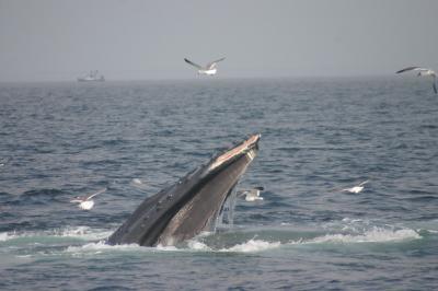
This is a humpback whale with a scrape on its jaw. Scientists say injuries such as this one are sometimes a result from bottom-feeding.
(Photo Credit: NOAA/Stellwagen Bank National Marine Sanctuary)
From this data, collected between 2004 and 2009, Ware and his collaborators identified three distinct types of behavior during what they call bottom side-roll feeding: simple side-rolls, side-roll inversions, and repetitive scooping. The tag data confirms the bottom-feeding that scientists had suspected from visible scarring along some whales' jaws.
Not only did the data show that these humpbacks, "by far the most acrobatic of all baleen whales," Ware says, were performing bottom side-rolls and seafloor scooping, it indicates that this bottom feeding does not include lunging, previously assumed to be the humpbacks' primary feeding behavior.
In lunge feeding, whales accelerates to propel water full of prey into their enlarged mouths; they then filter the water out through the hair-like filaments of their baleens and retain the prey. Tag data showed that the bottom-feeding humpbacks were moving at too low a speed to characterize this behavior as lunge feeding.
While a Crittercam™ – a National Geographic Society video camera that gives a whale's-eye view -- attached to a humpback provides additional insight into the whales' time at the seafloor, Ware cautions that there's plenty to learn about what the whales are doing in the deep.
"The big mystery is we still don't know exactly how they're feeding. We don't know the mechanism," he says.
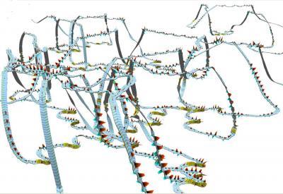
In this 3D computer visualization from UNH's Data Visualization Research Lab, the roller coaster-like movement of a tagged humpback whale in Stellwagen Bank National Marine Sanctuary is captured over a nearly two-hour period. The whale traveled at depths ranging from 30 to 150 feet deep. The red and blue triangles along the ribbon show the whale's powerful fluke, or tail fin, strokes that propel it through the water. The yellow sections along the ribbons indicate where bottom side-roll feeding occurs.
(Photo Credit: Colin Ware, University of New Hampshire Center for Coastal and Ocean Mapping)
Source: University of New Hampshire