Tropical Storm Bret's cloud tops are getting warmer on NASA infrared satellite imagery. That's an indication that the cloud top heights are dropping and Bret is weakening.
High cloud tops in thunderstorms are a clue that there's strong convective uplift. Uplift is the force of warm, moist, and unstable air upward into the atmosphere that condenses into the thunderstorms that power a tropical cyclone. When the uplift is weak, the convection is weak and thunderstorms are less intense than they could be. Bret is now experiencing a weaker convective uplift.
The Atmospheric Infrared Sounder (AIRS) instrument on NASA's Aqua satellite took an infrared look at Tropical Storm Bret on July 18 at 17:53 UTC (1:53 p.m. EDT). It showed cold high thunderstorm cloud tops to the south and west of the center of circulation. The coldest cloud top temperatures were cold as -63 Fahrenheit (-52 Celsius).
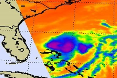
This infrared image of Tropical Storm Bret was captured from the AIRS instrument on NASA's Aqua satellite on July 18 at 17:53 UTC (1:53 p.m. EDT). The purple area in the center indicate strong thunderstorms with cloud top temperatures as cold as -63 Fahrenheit (-52 Celsius). The blue areas are warmer, less strong thunderstorms.
(Photo Credit: : NASA JPL, Ed Olsen)
So what caused the weakening in uplift and thunderstorm creation? Dry air moved into the center of Tropical Storm Bret and sapped the energy (moisture). Infrared data from AIRS on early on July 19 showed that strong convection and strong thunderstorms have almost disappeared from Bret's center.
At 5 a.m. EDT on July 19, Bret's maximum sustained wind were near 50 mph. It was located about 205 miles north-northeast of Great Abaco Island, bear 29.3 North and 76.4 West. In relation to the U.S. mainland, it's about 410 miles (660 km) south of Cape Hatteras, N.C. Bret continues to move to the open waters of the Atlantic in a north-northeasterly direction at 7 mph (11 kmh). Minimum central pressure is near 1000 millibars.
The National Hurricane Center noted today that all watches and warnings have been dropped. The forecasters there also expect Bret to speed up in the next day or two. Over that time, Bret will continue battling dry air and increasing wind shear. Those two ingredients will help weaken Bret. As a result of those two factors, the National Hurricane Center forecast indicates that Bret will likely dissipate by the weekend.
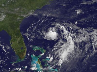
Visible imagery from the GOES-13 satellite at 1131 UTC (7:31 a.m. EDT) on July 19 shows a compact Tropical Storm Bret spinning in the Atlantic Ocean, some 410 miles (660 km) south of Cape Hatteras, N.C.
(Photo Credit: NASA/NOAA GOES Project)
Source: NASA/Goddard Space Flight Center