The NASA-NOAA Suomi NPP satellite saw the western edge of Tropical Storm Fung-Wong over the central Philippines on Sept. 18. Fung-Wong developed on Sept. 17 as Tropical Depression 16W, and strengthened into a tropical storm by 5 p.m. EDT on Sept. 17.
When NASA-NOAA's Suomi NPP satellite passed over Tropical Storm Fung-Wong on Sept. 18 at 05:24 UTC and the Visible Infrared Imaging Radiometer Suite (VIIRS) instrument aboard captured a visible picture of the storm. The VIIRS instrument revealed that a thick band of powerful thunderstorms spiraled around the southwestern quadrant of the storm and over the central Philippines.
On Sept. 18 at 1200 UTC (8 a.m. EDT), Tropical Storm Fung-Wong's maximum sustained winds were near 35 knots (40 mph/64 kph). It was centered near 16.0 north and 125.2 east about 284 nautical miles (326.8 miles/ 526 km) east-northeast of Manila, Philippines. Fung-Wong is moving to the west-northwest at 13 knots (14.9 mph/24.0 kph).
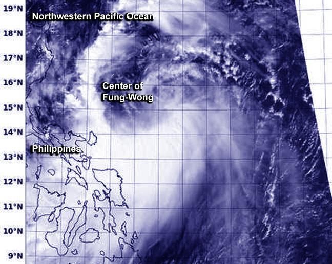
This visible image of Tropical Storm Fung-Wong was taken on Sept. 18 at 05:24 UTC from the VIIRS instrument aboard NOAA-NASA's Suomi NPP satellite.
(Photo Credit: Image : NRL/NOAA/NASA)
The Joint Typhoon Warning Center (JTWC) noted that although there is a chance for intensification, because Fung-Wong is so close to the Philippines, the land will limit how much strengthening can occur.
Fung-Wong is expected to move over the northern tip of Luzon where it will curve north and parallel Taiwan, while its center remains at sea. The JTWC then forecasts Fung-Wong to make landfall in Kyushu, Japan by September 23.
Source: NASA/Goddard Space Flight Center