Watches and Warnings in Effect
The National Hurricane Center has posted Warnings and Watches for Tropical Storm Issac. A Tropical Storm Warning is in effect for Martinique, Dominica, Guadeloupe and the surrounding islands, and St. Martin, St. Kitts, Nevis, Antigua, Barbuda, Montserrat, and Anguilla, Saba, St. Eustatius, and St. Maarten, British Virgin Islands, Puerto Rico, Vieques, Culebra, and the U.S. Virgin Islands.
There are also hurricane and tropical storm watches in effect. A Hurricane Watch is in effect for Puerto Rico, Vieques, Culebra, and the U.S. and British Virgin Islands; the south coast of the Dominican Republic from Isla Saona westward to the Haiti-Domenican Republic southern border. A Tropical Storm Watch is in effect for the north coast of the Dominican Republic from the Haiti-Dominican Republic northern border eastward to north of Isla Saona.
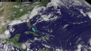
This animation of satellite observations from August 19-22, 2012, shows the development and movement of Tropical Storm Isaac toward the Lesser Antilles. This visualization was created by the NASA GOES Project at NASA Goddard Space Flight Center, Greenbelt, Md., using observations from NOAA's GOES-13 satellite.
(Photo Credit: NASA/NOAA GOES Project)
At 11 a.m. EDT (1500 UTC) on Aug. 22, Tropical Storm Isaac had maximum sustained winds near 45 mph (75 kmh), and the NHC said that strengthening is forecast. Isaac could become a hurricane by Thursday or Thursday night, Aug. 23. The center of Isaac was about 140 miles (230 km) east of Guadaloupe, near latitude 15.9 north and longitude 59.3 west. Isaac is moving westward near 21 mph (33 kmh) is expected to stay on this track over the next couple of days.
The NHC said, "On the forecast track the center of Isaac should move through the Leeward Islands this evening and pass near or south of the Virgin Islands and Puerto Rico on Thursday (Aug. 23) and approach the Dominican Republic Thursday night and Friday (Aug. 24).
System 95L Fizzles Out
The third low pressure area that forecasters had been watching for possible development has fizzled out, now that it moved inland in northeastern Mexico. The NHC gives it a "near zero percent" chance of development now.
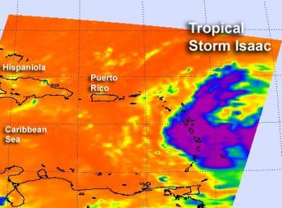
The Atmospheric Infrared Sounder (AIRS) instrument onboard NASA's Aqua satellite captured an infrared image of Tropical Storm Isaac on Aug. 22 at 2:05 a.m. EDT, as it was bringing heavy rainfall to the Lesser Antilles. Strong thunderstorms appeared in a band of thunderstorms in Isaac's western quadrant that had cloud top temperatures as cold as -63F (-52C) (in purple).
(Photo Credit: NASA JPL, Ed Olsen)
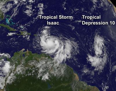
This visible image captured by NOAA's GOES-13 satellite on Aug. 22 at 1445 UTC shows Tropical Storm Isaac over the Lesser Antilles, and newborn Tropical Depression 10 trailing behind in the central Atlantic.
(Photo Credit: NASA/NOAA GOES Project)
Source: NASA/Goddard Space Flight Center