The data from the AIRS instrument is also used to create an accurate 3-D map of atmospheric temperature, water vapor and clouds, all of which are helpful to forecasters.
NOAA's GOES-13 satellite was providing real-time visible imagery of the severe weather outbreak when tornadoes were touching down around Maryland on June 1. The NASA GOES Project, located at NASA's Goddard Space Flight Center in Greenbelt, Md. combined the GOES imagery to create an animation of the severe weather outbreak. The animation that runs almost eight seconds shows the movement of the severe storms from 1:45 p.m. to 7:45 p.m. EDT (1745 UTC to 2345 UTC). The colorized full resolution uses the GOES visible data of the clouds, overlaid on a U.S. map created by imagery from the Moderate Resolution Spectroradiometer instrument (MODIS), an instrument that flies onboard both the NASA Aqua and Terra satellites.
The animation shows a cold front approaching from the west spawned severe storms along the U.S. East Coast, including 9 weak tornadoes in Maryland around sunset. From the GOES viewpoint, all that surface action is covered by cloud tops.
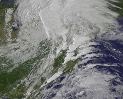
A cold front approaching from the west spawned severe storms along the East Coast, on June 1, 2012, including nine weak tornadoes in Maryland around sunset. From the GOES satellite viewpoint, all that surface action is covered by cloud tops. The image was created by the NASA GOES Project at NASA Goddard.
(Photo Credit: NASA GOES Project, Dennis Chesters)
Baltimore Meteorologist Justin Berk compiled a listing of the individual tornadoes. The ten tornadoes include: An EF-1 tornado with 90 mph winds in Pleasant Hills, Harford County; An EF-0 tornado started near Fort Meade and moved to BWI Marshall Airport; another tornado (not rated yet) in Gamber, Carroll County; an EF-O in Centreville in Queen Anne's County, Md. ; Two possible EF-0 tornadoes in Damascus, Montgomery County; An EF-0 at Springdale, Prince George's County (just outside the Washington, D.C. beltway); An EF-1 touched down in Watersville, Howard County; another EF-0 tornado touched down in Mount Airy in Carroll County; and another tornado (not yet rated) made an appearance in Simpsonville, Howard County.
NOAA's GOES-13 satellite captured a visible image of the severe weather outbreak when tornadoes were touching down around Maryland on June 1. This image was taken at 2215 UTC (6:15 p.m. EDT). The clouds that appear almost flat and positioned from southwest to northeast included the severe storms. The image was created by the NASA GOES Project at NASA Goddard.
(Photo Credit: NASA GOES Project)
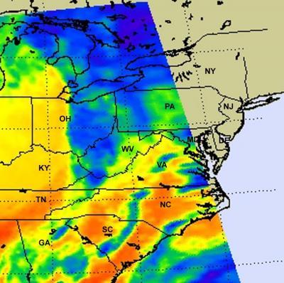
This infrared image from the AIRS instrument on NASA's Aqua satellite on June 1 at 18:53 UTC (2:53 p.m. EDT) shows the center of the most intense activity over West Virginia. That area appears to have cloud top temperatures between -27F and -45F, and the cloud tops are between 4.6 and 5.6 miles high.
(Photo Credit: NASA/JPL, Ed Olsen)
Source: NASA/Goddard Space Flight Center