The first tropical cyclone of the Southern Indian Ocean season lasted about one day. Tropical Cyclone 01S was born on Oct. 27 and by Oct. 28 had become a remnant low.
The first tropical cyclone of the Southern Indian Ocean cyclone season formed on Oct. 27 near 13.1 south and 63.4 east, about 570 nautical miles northeast of Port Louis, Mauritus. It was moving to the west-southwest at 7 knots. Maximum sustained winds were near 35 knots.
On Oct. 27, satellite imagery showed that the low-level circulation center is elongated indicating the system was battling wind shear. Satellite imagery revealed that the strongest convection was around the southern edge of the center. Maximum sustained winds were near 35 knots/40 mph/64.8 kph and the storm was moving west.
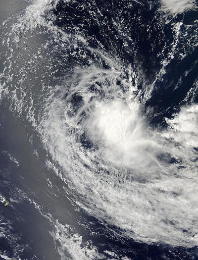
The MODIS instrument aboard NASA's Aqua satellite captured this visible image of Tropical Cyclone 01S in the South Indian Ocean. The image was taken on Oct. 27 at 09:30 UTC/4:30 a.m. EDT.
(Photo Credit: NASA Goddard MODIS Rapid Response Team)
The Moderate Resolution Imaging Spectroradiometer or MODIS instrument aboard NASA's Aqua satellite captured a visible image of Tropical Cyclone 01S in the South Indian Ocean. The image was taken on Oct. 27 at 09:30 UTC/4:30 a.m. EDT and showed an elongated storm.
On Oct. 28 at 0000 UTC/Oct. 27 at 8 p.m. EDT, Tropical Cyclone 01S was located near 13.1 south latitude and
62.5 east longitude, approximately 550 nautical miles north-northeast of La Reunion Island. Despite the maximum sustained winds near 35 knots/40 mph/64.8 kph, the storm was weakening and was expected to weaken because of wind shear.
Source: NASA/Goddard Space Flight Center