Landslides kill ten times more people across the world than was previously thought, according to research by Durham University, UK.
A new database of hazards shows that 32,300 people died in landslides between 2004 and 2010. Previous estimates ranged from 3,000 to 7,000 fatalities.
The database, which provides the first detailed analysis of fatal landslides across the world, maps hotspots including China, Central and South America, and India.
The researchers say that the new database, the Durham Fatal Landslide Database (DFLD), can help policymakers to prioritise areas for action to manage hazards and to lessen the risks to human populations living in hotspot regions.
The findings are published in the journal Geology.
Lead researcher, Professor David Petley, a Geographer at the International Landslide Centre, and Co-Director of The Institute of Hazard, Risk and Resilience, Durham University, said: "The environmental effects of landslides are often devastating for nearby human populations.
"We need to recognise the extent of the problem and take steps to manage what is a major environmental risk to people across the world. Our database will enable us to do this by identifying areas most at risk and could help to save thousands of lives."
The DFLD includes only fatal landslides and is compiled using a number of search tools and analysis of government statistics, aid agency reports, and research papers.
It is still likely that the database underestimates the number of landslides and deaths. The database excludes data from landslides caused by earthquakes due to the high level of uncertainty associated with these events. Following an earthquake, where there is a fatal landslide, the deaths are attributed to the earthquake trigger itself, rather than the landslide.
The researchers say that weather patterns, deforestation, melting permafrost in high mountainous areas, and high and increasing human population densities are important factors in the cause, distribution, number, extent and effects of landslides.
More fatal landslide events are recorded in May to October and the dominant global trigger is rain from the monsoon. Tropical cyclones also generate extreme rainfall events that trigger landslides in Asia, and hurricanes have the same effect on regions in the Caribbean and Central America.
This video shows the annual cycle of global and Asian fatal landslides (for the full dataset described in the research paper).They have been divided into the 52 weeks of the year -- for each week the map shows all of the landslides that occurred in that week of the year for the full dataset. Each dot is a single landslide. Note that in the early part of the year the focus is on South and Central America; in the middle part of the year (weeks 20 to 40) the focus shifts to Asia. In the first part of the northern hemisphere summer (weeks 20 to 30 or so) the landslides mostly occur in South Asia, later on this shifts to China. At the end of the year the concentration moves to Southeast Asia.This pattern reflects the global cycle of continental scale rainfall events, especially the Asian monsoon, which is mostly responsible for the triggering of landslides that kill people.
(Photo Credit: Professor Dave Petley, Durham University)
In some areas with a history of fatal landslides, such as Hong Kong, programmes to mitigate the risks of landslides have been successful.
Professor David Petley said: "Areas with a combination of high relief, intense rainfall, and a high population density are most likely to experience high numbers of fatal landslides. Landslides are a global hazard requiring a major change in perception and policy.
"There are things that we can do to manage and mitigate landslide risks such as controlling land use, proactive forest management, and guiding development away from vulnerable areas."
Global landslide hotspots:
- Southern edge of the Himalayan Arc
- South west coast of India
- Sri Lanka
- Southern and eastern coasts of China
- Central China, notably the mountains around the Sichuan Basin
- Western edge of the Philippine Sea plate (Japan, Taiwan and the Philippines)
- Central Caribbean islands including Haiti
- Indonesia, especially in Java
- Along the mountainous chain from Mexico, Central America, to Chile, South America, but especially in Colombia
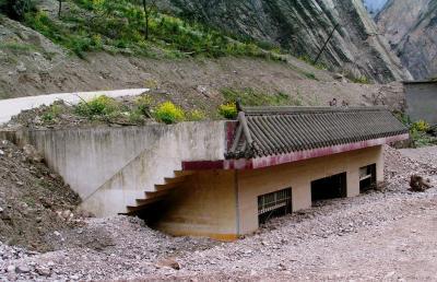
This is a buried house in Sichuan following a landslide.
(Photo Credit: Professor Dave Petley, Durham University)
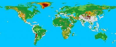
The background image shows global topography; each dot represents a single landslide that has killed a person.
(Photo Credit: Professor Dave Petley, Durham University)
Source: Durham University