At present the forest fires plaguing the area near James Bay in Quebec are causing air quality problems in the area and as far away as Maine. According to CBC News on July 02, 2013, "A smog warning is in effect for most of southwestern Quebec — from Gatineau to Montreal to Drummondville — and a smog advisory has already been effect for eastern Ontario, which was expanded all the way through Toronto and Hamilton. This current advisory is mostly due to smoke that is blowing into the warning areas from an extensive forest fire near James Bay, which has consumed around 250,000 hectares [~617,000 acres] of land so far."
A May 25 thunderstorm ignited the series of fires which have been burning ever since. The Bangor Daily News reports, "A northerly and northwesterly flow of air has pushed the smoke about 400 miles from northern Quebec near James Bay down to Maine. 'There is a front coming in that will push some of the smoke back, but it will not push out of northern Maine until later today [or] even tomorrow,' Webster [Martha Webster, Maine Department of Environmental Protection air quality meteorologist] said early Tuesday (July 2) afternoon.
At present the forest fires plaguing the area near James Bay in Quebec are causing air quality problems in the area and as far away as Maine. According to CBC News on July 02, 2013, "A smog warning is in effect for most of southwestern Quebec -- from Gatineau to Montreal to Drummondville -- and a smog advisory has already been effect for eastern Ontario, which was expanded all the way through Toronto and Hamilton. This current advisory is mostly due to smoke that is blowing into the warning areas from an extensive forest fire near James Bay, which has consumed around 250,000 hectares [~617,000 acres] of land so far."
A May 25 thunderstorm ignited the series of fires which have been burning ever since. The Bangor Daily News reports, "A northerly and northwesterly flow of air has pushed the smoke about 400 miles from northern Quebec near James Bay down to Maine. 'There is a front coming in that will push some of the smoke back, but it will not push out of northern Maine until later today [or] even tomorrow,' Webster [Martha Webster, Maine Department of Environmental Protection air quality meteorologist] said early Tuesday (July 2) afternoon.
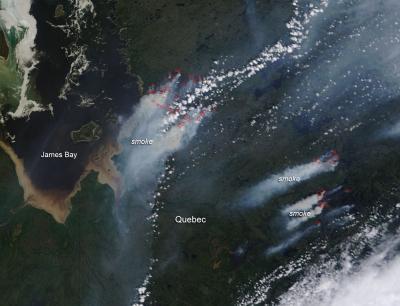
This natural-color satellite image was collected by the Moderate Resolution Imaging Spectroradiometer (MODIS) aboard the Aqua satellite on June 02, 2013. Actively burning areas, detected by MODIS's thermal bands, are outlined in red.
(Photo Credit: NASA image courtesy Jeff Schmaltz, MODIS Rapid Response Team. Caption: NASA/Goddard, Lynn Jenner)
This natural-color satellite image was collected by the Moderate Resolution Imaging Spectroradiometer (MODIS) aboard the Aqua satellite on June 02, 2013. Actively burning areas, detected by MODIS's thermal bands, are outlined in red.
Source: NASA/Goddard Space Flight Center