Alexandria, VA - In a field like earth science, adventures in the outdoors are commonplace. As this summer's field season comes to a close and the lanterns are extinguished one last time, EARTH Magazine explores the ritual of field camp as geoscientists' rite of passage from classroom learner to a workforce-ready scientist.
Earth science is just that, the study of the Earth. Thorough understanding of the surface expression of textbook concepts helps geoscientists provide protection and valuable resources to society. Thousands of U.S. college students participate in field camps each year, staying in accommodations varying from lodges with running water to nomadic tent camps — where they backpack into sites in the middle of nowhere to see, experience and comprehend the landforms people take for granted. No longer are students reading books, rather they're reading the rocks.
The history of geology field camps dates back to the days of great explorers and naturalists like John Muir and his contemporaries. Now young men and women gear up and pack out to geologically unique locations nationwide. While traditional skill of mapping rock units and structures onto a blank topographic map still represents a foundational skill set, faculty and industry professionals are finding ways to integrate relevant technology to keep students workforce-ready.
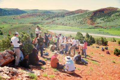
Near the site of Wyoming's first oil well, drilled in 1885 in the Dallas Dome, students in the University of Missouri's field camp listen and take notes.
(Photo Credit: Copyright Miriam Barquero-Molina)
Students leave field camp with a varied toolkit that utilizes colored pencils as much as geophones and GPS. Share in the adventures of thousands in this month's EARTH Magazine cover story at: http://bit.ly/124d77x.
Source: American Geosciences Institute