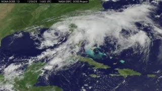
On Wednesday, June 27, 2012 at 5 a.m. EDT (0900 UTC), Debby's maximum sustained winds were near 35 knots (55 kmh). It was located about 25 miles (45 km) southeast of St. Augustine, Florida, near latitude 29.6 north and longitude 81.0 west. Debby is moving east-northeast near 10 mph (17 kmh) and is expected to continue in this direction over the next couple of days while speeding up. Debby should gradually move away from Florida today, according to the National Hurricane Center.
A visible image of Tropical Depression Debby was taken from NOAA's GOES-13 satellite on Wednesday, June 27 at 8:31 a.m. EDT. It showed that t bulk of Debby's clouds and showers were over the Atlantic and coupled with a frontal system as Debby's center is now moving off the eastern shore of Florida. NOAA manages the GOES-13 satellite and NASA's GOES Project at the NASA Goddard Space Flight Center in Greenbelt, Md. uses the data to create images and animations.
The National Hurricane Center noted that some re-strengthening is possible as the system moves to the northeast and away from Florida.
An animation of satellite observations shows the progression of Tropical Storm Debby from June 25-27, 2012. The animation shows that Tropical Storm Debby's center move from the northeastern Gulf of Mexico into the Atlantic Ocean. Clouds around the center appear to fade in infrared imagery and are more evident in visible imagery. The strongest storms appear east of the center. This visualization was created by the NASA GOES Project at NASA Goddard Space Flight Center, Greenbelt, Md., using observations from NOAA's GOES-13 satellite.
(Photo Credit: NASA/NOAA GOES Project Center)
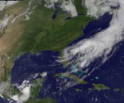
This visible image of Tropical Depression Debby was taken from NOAA's GOES-13 satellite on Wednesday, June 27, at 8:31 a.m. EDT. The bulk of Debby's clouds and showers were over the Atlantic and coupled with a frontal system, as Debby's center (the tight swirl over central eastern Florida) is now moving off the eastern shore of Florida.
(Photo Credit: NASA GOES Project)
Source: NASA/Goddard Space Flight Center