Taking a dip in a freshwater lake can quickly lose its appeal on contact with slippery aquatic plants. These might include Elodea nuttallii and Najas marina, better known as western waterweed and spiny naiad, both of which have been spreading rapidly in German water bodies in recent years.
Ecologists are able to use them as indicator plants. Their proliferation allows researchers to draw conclusions on water quality – Elodea nuttallii and Najas marina are particularly common in lakes with rising water temperatures. The rapid spread of such plants over a wide area can upset the balance of sensitive lake ecosystems.
Satellite images support research divers
To investigate changes in lake ecosystems, water management authorities regularly monitor plant populations. This requires the observations of divers, who map the "vegetation blankets" at different depths.
This process does produce highly detailed information, but it requires a lot of effort. Doctoral students from TUM's Limnological Research Station in Iffeldorf have carried out research on this topic for their dissertations. The result of their work is a new process that will save both time and money.
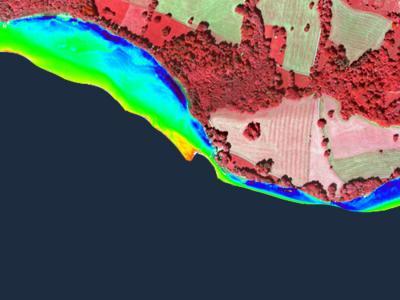
With the help of aerial images -- such as this one showing the western shore of Lake Starnberg -- scientists are able to track the spread of certain aquatic plants. This information sheds light on the quality of the water (blue: bare sediment; green and yellow: sparse vegetation; dark red: dense vegetation).
(Photo Credit: Landesamt für Vermessung und Geodäsie)
"This new idea involves replacing some of the diving effort with high-resolution aerial and satellite images," explains project supervisor Dr. Thomas Schneider. "In order to draw conclusions on plant growth from the imagery produced, we measure reflectance. Each plant species reflects the incident light in a specific way, depending on its pigmentation and structure."
Every lake has its own reflectance characteristics
The researchers developed a digital library with the spectral characteristics of plants to help them evaluate the aerial and satellite images. This was a lengthy process, however, as doctoral student Patrick Wolf explains: "It took us two years to photograph the plants from a boat and measure their reflectance. In order to capture the plants from a suitable angle and avoid shadow, the cameras and sensors were submerged using an extension arm."
The problem is that factors like dissolved matter, sediment type, light refraction and different depths of water make it hard to assess plant populations. That is why the researchers developed mathematical algorithms to "factor out" the image errors in combination with the measurement data from the boat. Since every body of water has its own distinct characteristics, a different algorithm was developed for each lake.
Early detection of ecosystem risks
The new method is best suited for monitoring large, uniform plant populations. "We will still need divers to inspect areas with small-scale changes in vegetation," says Wolf. "The aerial view cannot replace the work of the divers, but it can provide effective support."
The TUM limnologists have developed a remote sensing method for regularly monitoring larger plant populations in lakes. This makes it easier and more cost-effective to identify unwelcome developments. Plants like spiny naiad and waterweed are not just a nuisance for swimmers – their spread also has the potential to change the ecosystem of a body of water in the long term. They could, for example, displace other species or alter the habitats of different organisms like fish.
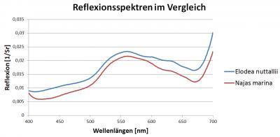
Aquatic plants reflect light in different ways. Their reflectance spectra give scientists a bird's-eye view of the spread of both plant species.
(Photo Credit: P. Wolf/TUM)
Source: Technische Universitaet Muenchen