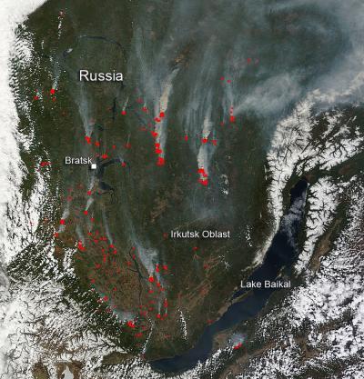
Lake Baikal, which is usually still frozen over at this time of year, can clearly be seen in the image. At this time, though, the lake has lost all of its ice coverage already even though snow still surrounds it. Temperatures in this region have skyrocketed in the past few weeks to the 70s prompting outbreaks of fires. Temperatures are usually cooler until late July/early August when the bulk of the wildfires in this area normally erupt. Careless handling with fire and withered dry grass fires on the croplands reportedly were the main reasons for the fires.
The Voice of Russia reports, "The Siberian Federal District reported 52 forest fires on an area of 53,644.1 hectares (132,557 acres) as of Thursday morning, the district department of the Federal Forestry Agency said. The wildfire rate is the highest in the Trans-Baikal territory - twelve fires burning on 48,150 (118,981 acres) hectares. There are 13 fires on 2,578.5 (6,370 acres) hectares in the Krasnoyarsk territory and four fires on 2,229 (5,507 acres) hectares in the Omsk region, the report runs."
Of note: Lake Baikal is 636 kilometers long (395 miles). It is the deepest lake in the world and by volume holds the largest amount of fresh water.
Temperatures in this region have skyrocketed in the past few weeks to the 70s prompting outbreaks of fires.
(Photo Credit: NASA image courtesy Jeff Schmaltz, MODIS Rapid Response Team.)
This natural-color satellite image was collected by the Moderate Resolution Imaging Spectroradiometer (MODIS) aboard the Terra satellite on May 18, 2014. Actively burning areas, detected by MODIS's thermal bands, are outlined in red. NASA image courtesy Jeff Schmaltz, MODIS Rapid Response Team. Caption: NASA/Goddard, Lynn Jenner with information from The Voice of Russia
Source: NASA/Goddard Space Flight Center