The sixth tropical depression of the Atlantic Ocean Hurricane Season formed in the Eastern Atlantic Ocean and NOAA's GOES-East satellite captured it.
A visible image of Tropical Depression 6 was taken by NOAA's GOES-East satellite at 7:45 a.m. EDT on September 11 as it developed. The image was created by NASA/NOAA's GOES Project at the NASA Goddard Space Flight Center in Greenbelt, Maryland.
In addition to using GOES imagery and data from other NOAA and NASA satellites, The National Hurricane Center also uses measurements from the Advanced Scatterometer or ASCAT instrument that flies aboard the EUMETSAT METOP satellite. Forecaster Beven at the National Hurricane Center noted "Satellite imagery and a recent ASCAT-B overpass indicate that the low pressure area over the eastern Atlantic has a well-defined circulation and organized convective banding near the center."
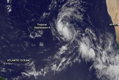
This visible image of Tropical Depression 6 was taken by NOAA's GOES-East satellite at 7:45 a.m. EDT on Sept. 11 as it developed.
(Photo Credit: NASA/NOAA GOES Project)
At 11 a.m. EDT Tropical Depression Six had maximum sustained winds near 35 mph (55 kph) and the depression could become a tropical storm later in the day. The center of Tropical Depression Six was located near latitude 16.2 north and longitude 37.1 west, about 870 miles (1,400 km) west of the Cape Verde Islands. The depression is moving toward the northwest near 13 mph (20 kph) and is expected to move northwest or west-northwest is expected during the next couple of days. The estimated minimum central pressure is 1007 millibars.
Despite being in an area of wind shear, the NHC noted that computer model guidance forecasts slow but steady strengthening.
Source: NASA/Goddard Space Flight Center