NASA's TRMM satellite noticed that as Tropical Storm Washi approached the Philippines' island of Mindanao heavy rainfall had become more widespread than the previous day. NASA's Terra satellite captured Washi making landfall early today.
Early on Dec. 15 when NASA's Tropical Rainfall Measuring Mission (TRMM) satellite passed over Tropical Storm Washi, (known as Sendong in the Philippines) there was one area to the southwest of the center that had heavy rainfall. When TRMM passed over Washi later on Dec. 15 at 1515 UTC (10:15 a.m. EST), heavy rainfall was more widespread throughout the entire storm. TRMM saw areas of heavy rain, falling at 2 inches (50 mm) per hour, in the east, north and western quadrants of the storm.
That rainfall analysis was created at NASA's Goddard Space Flight Center in Greenbelt, Md. using the TRMM Microwave Imager (TMI) and Precipitation Radar (PR) data overlaid on an enhanced infrared image from the satellite's Visible and InfraRed Scanner (VIRS). The rainfall analysis showed that Washi was much better organized and bands of thunderstorms spiraling into the center of the storm.
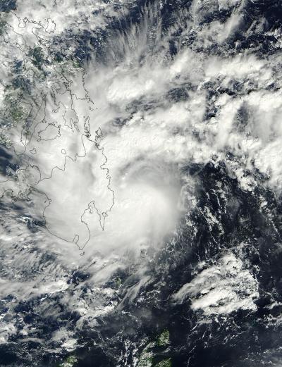
NASA's Terra satellite flew over Tropical Storm Washi on Dec. 16 at 01:45 UTC and captured this visible image of the storm. The western half of Washi was already over Minandao in the southern Philippines.
(Photo Credit: : NASA Goddard MODIS Rapid Response Team)
TRMM PR data was also used to create a 3-D image from the same satellite overpass and showed numerous heavy thunderstorms were located throughout the tropical cyclone. The tallest thunderstorms reached heights of over 15 km (~9.3 miles) and were located in the feeder bands converging into northwest side of the storm.
On Dec. 16 at 01:45 UTC, NASA's Terra satellite flew over Tropical Storm Washi and captured a visible image of the storm using the Moderate Resolution Imaging Spectroradiometer (MODIS) instrument. MODIS showed the western half of Washi was already over Mindanao in the southern Philippines. Mindanao is the second largest and easternmost island of the Philippines.
Warnings in effect in the Philippines for Dec. 16 include: Public storm warning signal #2 for Mindanao: Misamis Oriental & Occidental, Camaguin Island, Bukidnon, Lanao del Norte & Sur and Zamboanga Provinces. Public storm warning signal #1 is in effect for Mindanao: Bohol, Siquijor, Southern Cebu, Negros Oriental and Southern Negros Occidental; and for Visayas: Surigao Del Norte, Agusan del Norte & Sur, Davao del Norte, Compostela Valley, North Cotabato and Maguindanao; and in Luzon: Palawan.
At 1500 UTC (10 a.m. EST) on Dec. 16, Tropical Storm Washi's maximum sustained winds were near 50 knots (57 mph/92 kmh). Those tropical storm-force winds extend out 50 miles (80 km) from the center making the storm over 100 miles in diameter.
Washi was about 230 miles (370 km) east-northeast of Zamboanga, in Minandao Philippines near 8.4 North and 125.5 East. Washi was moving to the west-northwest at 13 knots (15 mph/24 kmh) but slowing down as it interacts with land. As Washi slowed, the Joint Typhoon Warning Center (JWTC)noted that convection (rising air that forms thunderstorms that make up the tropical storm) and thunderstorms spread to all quadrants of the storm. The strongest thunderstorms appeared over the southwestern quadrant this morning.
Washi was making landfall over Mindanao on Dec. 15 at 1500 UTC and will continue moving westward. The JTWC expects Washi to re-intensify over the Sulu Sea and make a final landfall this weekend in Vietnam.
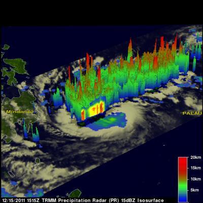
This TRMM 3-D image created from data on Dec. 15, showed Tropical Storm Washi's tallest thunderstorms reached heights of over 15 km (~9.3 miles) and were located in the feeder bands converging into northwest side of the storm.
(Photo Credit: : NASA/SSAI, Hal Pierce)
Source: NASA/Goddard Space Flight Center