NASA satellites are providing valuable data to forecasters as Tropical Cyclone Iggy nears Western Australia. NASA's Aqua satellite provided visible and infrared data on Iggy, observing colder cloud tops and strengthening storm. Iggy has already triggered warnings and watches along coastal areas.
The Australian Bureau of Meteorology (ABM) has issued a Cyclone Warning for coastal areas from Mardie to Ningaloo including Exmouth and Onslow. ABM has also issued a Cyclone Watch east to Port Hedland and south to Coral Bay. In addition, a Blue Alert has been posted for "People in or near coastal and island communities between Mardie and Coral Bay including the communities of Mardie, Onslow, Exmouth and Coral Bay need to prepare for cyclonic weather."
The Moderate Resolution Imaging Spectroradiometer (MODIS) instrument aboard NASA's Aqua satellite captured a true color image of Tropical Storm Iggy on January 27 at 0655 UTC (2:30 a.m. EST), and showed Iggy as a rounded area of clouds with no visible eye. Animated infrared satellite imagery showed a slight cooling of cloud tops in Iggy's main band of thunderstorms, located west of the center. Dropping cloud-top temperatures mean that the strength in the storm is increasing and pushing those cloud tops higher in the atmosphere, where it is colder. Higher cloud tops mean stronger thunderstorms within the tropical cyclone.
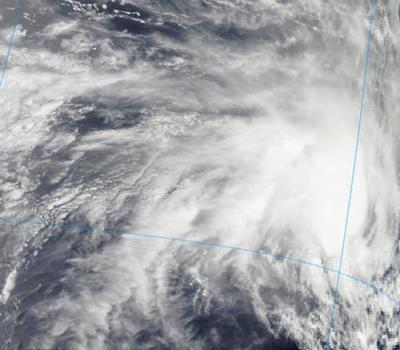
NASA's Aqua satellite passed over the Southern Indian Ocean and its MODIS instrument captured a visible image of Tropical Storm Iggy on Jan. 27 at 0655 UTC (2:30 a.m. EST). The MODIS instrument captured a true color image of the storm that showed Iggy as a rounded area of clouds.
(Photo Credit: : NASA Goddard MODIS Rapid Response Team)
At 1500 UTC (10 a.m. EST) on January 27, Iggy's maximum sustained winds were near 55 knots (63 mph/102 kph). Iggy's tropical-storm-force-winds extend 115 nautical miles (132 miles/213 km) from the center. Iggy is about 230 nm (~265 miles/426 km) in diameter. Iggy was centered about 270 nautical miles (~311 miles/500 km) northwest of Learmouth, Australia, near 19.1 South latitude and 110.7 East longitude. Iggy is moving slowly to the south-southeast, toward Western Australia's Pilbara coastline.
ABM classified Iggy as a "Category two" cyclone, with wind gusts of 130 kph (~81 mph). ABM forecasters expect Iggy to become a category three storm on January 28. For updates on tropical cyclone warnings from the ABM, visit: http://www.bom.gov.au/cyclone/.
Because of low wind shear and warm waters, Iggy is expected to continue strengthening on its approach to the Australian coastline. The Joint Typhoon Warning Center forecast as of January 27 takes the center of Iggy's center very close to Learmouth on January 30 and 31 before turning to the southwest and heading back to sea.
Source: NASA/Goddard Space Flight Center