Rainfall data from NASA's TRMM satellite revealed that parts of Madagascar's east coast received over a foot (30 cm) of rainfall from Cyclone Giovanna's passage, and new satellite data shows Cyclone Giovanna re-strengthening and turning back toward southeastern Madagascar.
The Tropical Rainfall Measuring Mission (TRMM) satellite, managed by both NASA and the Japanese Space Agency obtains rainfall rate data from space and acts like a flying rain gauge. That data is analyzed to determine how much rain falls from certain events. In a Multi-satellite Precipitation Analysis (TMPA) done at the NASA Goddard Space Flight Center in Greenbelt, Md. on Cyclone Giovanna's rainfall from February 8-15, 2012, the highest rainfall totals of over 250mm (~10 inches) fell in the coastal area east of Madagascar's capitol of Antananarivo. In that area people were flooded out of their homes and deaths have been reported.
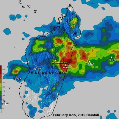
Cyclone Giovanna's rainfall from Feb. 8-15, 2012, the highest rainfall totals of over 250mm (~10 inches) fell in the coastal area east of Madagascar's capitol of Antananarivo. In that area people were flooded out of their homes and deaths have been reported. White symbols show the times and locations of tropical cyclone Giovanna as it passed over Madagascar.
(Photo Credit: SSAI/NASA, Hal Pierce)
Giovanna then tracked across central Madagascar and entered the Mozambique Channel where the warm waters re-energized the storm.
On February 17, 2012, NASA's Aqua satellite flew over Cyclone Giovanna. On infrared imagery from the Atmospheric Infrared Sounder (AIRS) instrument, bands of thunderstorms from northeast to southeast of the center of Cyclone Giovanna appeared strong in an image captured at 1023 UTC (5:23 a.m. EST).
Five hours later at 1500 UTC (10 a.m. EST), Giovanna's maximum sustained winds were near 55 knots (63.3 mph/102 kph). The center of circulation was about 445 nautical miles (512 miles/824 km) south-southwest of Antananarivo, Madagascar, near 25.8 South and 43.2 East. It was moving southeastward at 2 knots (2.3 mph/3.7 kph).
The forecasters at the Joint Typhoon Warning Center expect Giovanna to track over southern Madagascar over the weekend of February 18 and 19 with gusty winds and heavy rainfall. Giovanna is expected to then dissipate over the southeastern part of the island by February 20.
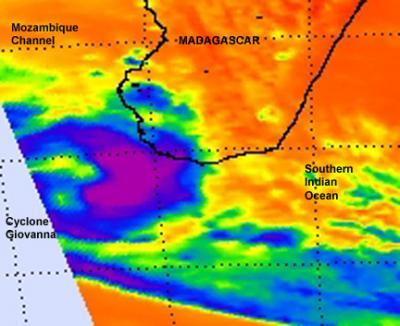
On infrared imagery from the NASA AIRS instrument, some thunderstorms from northeast to southeast of the center of Cyclone Giovanna were strong (purple) on imagery captured on Feb. 17, 2012 at 1023 UTC (5:23 a.m. EST).
(Photo Credit: NASA JPL, Ed Olsen)
Source: NASA/Goddard Space Flight Center