Tiny Tropical Storm Michael formed today, Sept. 4, from the thirteenth tropical depression in the Atlantic Ocean, but it seems that wind shear will make Michael struggle to intensify over the next couple of days like his "sister" Tropical Storm Leslie. Isaac's remnants blanket the U.S. east coast.
Leslie has been a tropical storm since late Aug. and has not yet reached hurricane strength because of wind shear, although that is expected to change. Isaac's remnants are also struggling, but struggling to get off the land and back into the Atlantic Ocean. Isaac's remnants are now associated with a stationary frontal system over the U.S. east coast. The storm made landfall in Louisiana as a hurricane on Aug. 29.
NOAA's GOES-13 satellite captured an image of Isaac's huge blanket of clouds over the U.S., large Tropical Storm Leslie headed to Bermuda (Leslie is about 400 miles in diameter), and very small Tropical Storm Michael far to the east of Leslie, and located in the central Atlantic. Michael is more than seven times smaller than Leslie, as tropical-storm force winds only extend out 35 miles (55 km) from the center, making Michael about 70 miles in diameter. The image was created by the NASA GOES Project at NASA Goddard Space Flight Center in Greenbelt, Md.
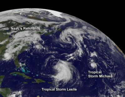
NOAA's GOES-13 satellite captured an image of Isaac's huge blanket of clouds over the US, large Tropical Storm Leslie headed to Bermuda (Leslie is about 400 miles in diameter), and very small Tropical Storm Michael far to the east of Leslie, and located in the central Atlantic. The larger system north of Leslie is a cold-core, low pressure system.
(Photo Credit: NASA GOES Project)
On Sept. 4 at 11 a.m. EDT, Michael's maximum sustained winds were near 40 mph (65 kmh). Michael was located about 1,220 miles (1,965 km) southwest of the Azores, near latitude 27.0 north and longitude 43.5 west. Michael is moving toward the north-northwest near 5 mph (7 kmh) and expected to move more toward the north in the next couple of days while not strengthening much, according to the National Hurricane Center.
According to NOAA's Hydrometeorological Prediction Center, most of the remnants of Tropical cyclone Isaac are now part of an elongated center of low pressure over the Alabama-Georgia border that is spreading clouds and showers along the U.S. east coast. That center is expected to move south of south-southwest while an upper level low pressure area near Miami moves north-northwestward.
Source: NASA/Goddard Space Flight Center