Tropical Cyclone 15S has had a difficult "childhood." It was born on March 1 and immediately dealt with a harsh environment. The cyclone weakened within 24 hours to a remnant low pressure area, and NASA's TRMM satellite revealed there was still some strength remaining in the storm.
The Tropical Rainfall Measuring Mission (TRMM) satellite passed over the remnants of Tropical Cyclone 15S in the South Indian Ocean on March 2, 2012 at 0140 UTC (8:40 p.m. EST, March 1). A rainfall analysis from TRMM's Microwave Imager (TMI) and Precipitation Radar (PR) instruments showed very heavy rainfall of over 50mm/hr (~2 inches) was occurring near the center of the storm's circulation.
TRMM's Precipitation Radar (PR) was used to create a 3-D image of the remnants of Tropical Cyclone 15S' structure. Powerful thunderstorm towers in the middle of the remnant low were seen to reach heights of over 17.5 (~10.9 miles). "Another indication of heavy rainfall was that radar reflectivity values of 53.770 dBz were found in this area of the tropical cyclone," said Hal Pierce of the TRMM satellite team at NASA's Goddard Space Flight Center in Greenbelt, Md. where the images were created.
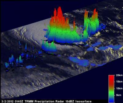
TRMM's Precipitation Radar was used to create a 3-D image of the remnants of Tropical Cyclone 15S' structure. Powerful thunderstorm towers in the middle of the storm were seen to reach heights of over 17.5 (~10.9 miles).
(Photo Credit: : NASA/SSAI, Hal Pierce)
The Joint Typhoon Warning Center issued their final warning on Tropical Cyclone 15S on March 1 at 2100 UTC (4 p.m. EST) when its maximum sustained winds were near 30 knots (34.5 mph/55.5 kph). It was located about 460 nautical miles (529 miles/852 km) northeast of Port Louis, Mauritus at that time. That's near 15.3 South and 63.7 East.
On March 2, Tropical Cyclone 15S's remnants were located near 16.4 South and 63.2 East, approximately 400 nautical miles (460 miles/~741 km) northeast of Port Louis, Maritius. Infrared satellite imagery showed that strong convection (rising air that forms the thunderstorms that make up a tropical cyclone) was occurring near the center of the low pressure area. In the southwestern quadrant of the low, however, the air was sinking (subsidence) so thunderstorm development was being prevented.
Satellite data also showed that the low-level center was elongated from northwest to southeast, as a result of an upper level trough (elongated area) of low pressure.
The remnants of Tropical Cyclone 15S are expected to keep tracking west and may re-develop as wind shear weakens and it moves through warm sea surface temperatures. The Joint Typhoon Warning Center gives the remnants a medium chance of regaining tropical depression status over the weekend of March 3 and 4, 2012.
Source: NASA/Goddard Space Flight Center