At 11 a.m. EDT on Wednesday, August 27, Cristobal's maximum sustained winds were near 80 mph (130 kph) and some strengthening is possible. It was centered near latitude 31.8 north and longitude 72.2 west. That puts the center of Cristobal about 435 miles (700 km) west of Bermuda and even closer to Cape Hatteras, North Carolina at 300 miles (485 km) to the Cape's southeast.
Cristobal has a large wind field where hurricane force winds extend outward from the center up to 60 miles (95 km) and tropical storm force winds extend outward up to 205 miles (335 km). The estimated minimum central pressure is 983 millibars.
Cristobal is moving toward the north near 12 mph (19 kph) and the National Hurricane Center (NHC) expects a turn to the northeast. NHC noted that the center of Cristobal will pass well northwest of Bermuda late on August 27 and stay away from the U.S. and Canadian mainland on its track to the North Atlantic Ocean.
Cristobal is expected to become a powerful extra-tropical cyclone over the north Atlantic by Friday, August 29.
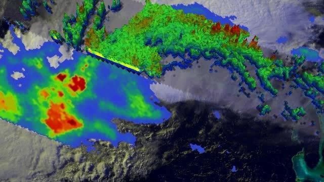
NASA's TRMM Satellite Sees Powerful Towering Storms in Cristobal On Aug. 26, NASA's TRMM Satellite saw a band of thunderstorms with heights of over 15km (about 9.3 miles) and was generating heavy rain. That band was wrapping into the center of Cristobal.
(Photo Credit: Image : NASA/SSAI, Hal Pierce)
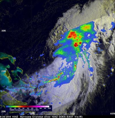
On Aug. 26, NASA's TRMM Satellite saw a band of thunderstorms with heights of over 15km (about 9.3 miles) and was generating heavy rain. That band was wrapping into the center of Cristobal.
(Photo Credit: Image : NASA/SSAI, Hal Pierce)
Source: NASA/Goddard Space Flight Center