Tropical Storm Nadine's life story during the week of Sept. 11 has been about the storm's continual struggle to become a hurricane. NASA's TRMM satellite captured a look at the rainfall and towering clouds within Nadine as the system continues to deal with wind shear and dry air that are keeping it under hurricane status.
On Sept. 14 at 5 a.m. EDT Tropical Storm Nadine's maximum sustained winds were still near 70 mph (110 kmh). Nadine has been battling wind shear during the week of Sept. 11 and is moving into an area where upper-level winds are not favorable for enabling further development, which means that Nadine is expected to remain a tropical storm in the near term.
Nadine was located about 800 miles (1,290 km) northeast of the Northern Leeward Islands and about 765 miles east-southeast of Bermuda, near 26.3 north latitude and 54.1 west longitude. Nadine is moving toward the north-northwest near 15 mph (24 kmh) and is expected to turn north then northeast over the weekend of Sept. 15. Nadine's estimated minimum central pressure was 988 millibars.
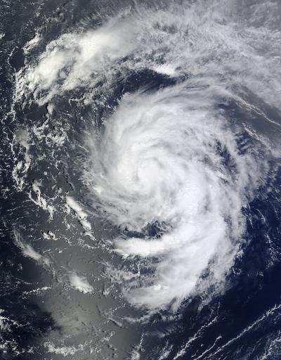
NASA's Terra satellite passed over Tropical Storm Nadine in the Atlantic Ocean on Sept. 12 at 10:10 a.m. EDT and captured this visible image of the storm.
(Photo Credit: NASA Goddard/MODIS Rapid Response Team)
Satellite imagery on Sept. 14 revealed that Nadine has grown in size. Tropical-storm-force winds now extend outward up to 230 miles (370 km) from the center. Satellite data on Sept. 14 showed Nadine looking more ragged and disorganized, as the convection (rising air that forms the thunderstorms that make up the tropical cyclone) have decreased in area and intensity around the center of circulation. In addition, the thunderstorm banding in the eastern semicircle had also diminished early on Sept. 14, indicating that Nadine was still dealing with dry air and wind shear.
The Tropical Rainfall Measuring Mission or TRMM satellite had a very good view of tropical storm Nadine in the central Atlantic Ocean on Sept. 13 at 1047 UTC ( 6:47 a.m. EDT). A rainfall analysis using data from TRMM's Microwave Imager (TMI) and Precipitation Radar (PR) instruments showed that rain was falling at a rate of over 75mm (~3 inches) per hour in convective storms just northeast of Nadine's center of circulation.
At NASA's Goddard Space Flight Center in Greenbelt, Md., Hal Pierce of NASA's TRMM team created a 3-D view of Tropical Storm Nadine using data from TRMM's Precipitation Radar instrument. The 3-D view showed some towers near Nadine's center were reaching heights of 16km (~9.94 miles). Energy released by the latent heat of condensation with heavy rain in these convective towers can serve to invigorate a tropical cyclone.
NASA's TRMM satellite is like a rain gauge in space and can measure rainfall from its position in orbit. TRMM is managed by NASA and the Japanese Space Agency, JAXA.
Dry air entrainment and southwesterly wind shear have kept Nadine from becoming a hurricane. The National Hurricane Center (NHC) predicts that Nadine will overcome these negative environmental conditions and still become a hurricane.
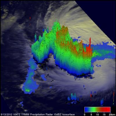
NASA's TRMM satellite passed over Tropical Storm Nadine on Sept. 13 at 6:47 a.m. EDT and saw that rain was falling at a rate of over 75mm (~3 inches) per hour in convective storms just northeast of Nadine's center of circulation.
(Photo Credit: Hal Pierce, NASA/SSAI)
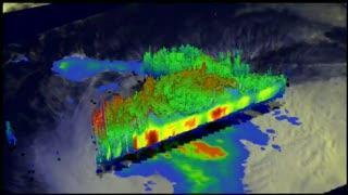
This flyby 3-D view of Tropical Storm Nadine on Sept. 13, 2012, was created using data from NASA's TRMM satellite. It shows that some towers near Nadine's center were reaching heights of 16km (~9.94 miles).
(Photo Credit: Hal Pierce, NASA/SSAI)
Source: NASA/Goddard Space Flight Center