Hot towers, or towering thunderclouds that give off an excessive amount of latent heat, usually indicate a tropical cyclone will strengthen in six hours, and NASA's TRMM satellite saw some of them as it passed by Tropical Storm Koji.
The Tropical Rainfall Measuring Mission (TRMM) satellite passed directly above an intensifying tropical storm in the South Indian Ocean called Koji on March 8, 2012 at 2053 UTC (3:53 p.m. EST). A rainfall analysis was made from TRMM Microwave Imager (TMI) and Precipitation Radar (PR) data. Those TRMM data reveal that Koji was getting organized with bands of heavy rainfall spiraling into the storm's center.
One of its most important features of TRMM's Precipitation Radar (PR) instrument is its ability to provide three dimensional profiles of precipitation from the surface up to a height of about 20km (12 mile). PR data from the flight over tropical storm Koji are shown in the 3-D image above. Those data reveal that an eye hadn't formed but powerful storm towers around KOJI's center were reaching heights of almost 15 km (~9.3 miles).
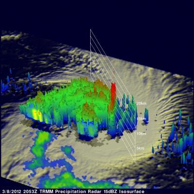
TRMM data from the flight over tropical storm Koji are shown in the 3-D image above. Those data reveal that an eye hadn't formed but powerful storm towers around KOJI's center were reaching heights of almost 15km (~9.3 miles).
(Photo Credit: NASA/SSAI, Hal Pierce)
On March 8, 2012 at 0900 UTC (4 a.m. EST), Tropical Storm Koji had maximum sustained winds near 55 knots (63.2 mph/102 kph). It was located near 17.1 South and 86.1 East, about 1000 miles southeast of Diego Garcia and moving to the west at 12 knots (13.8 mph/22.2 kph).
Koji has been predicted to increase in intensity and reach hurricane force with peak winds of 70kts (~80 mph) on March 8, 2012. Koji is predicted to remain at hurricane force for only one day and then weaken while traveling southwestward of the open waters of the South Indian Ocean.
Source: NASA/Goddard Space Flight Center