NASA's TRMM satellite revealed that Tropical Storm Daniel's most concentrated rainfall is occurring around the storm's center.
When the Tropical Rainfall Measuring Mission (TRMM) satellite passed over Tropical Storm Daniel on July 6, 2012 at 0034 UTC, data revealed heavy rain falling around the southern periphery of the center of circulation. The heavy rain was falling at a rate of more than 2 inches/50 mm per hour. TRMM is jointly managed by both NASA and the Japanese Space Agency, JAXA.
Daniel remains no threat to land, however, as the storm is expected to continue on a westward track into the open waters of the eastern Pacific over the weekend.
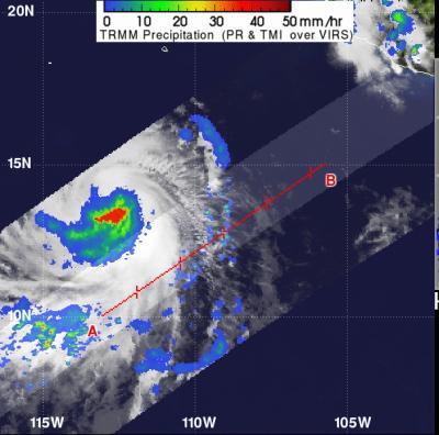
The TRMM satellite passed over Tropical Storm Daniel on July 6, 2012, at 0034 UTC and data revealed heavy rain falling around the southern periphery of the center of circulation. The heavy rain (in red) was falling at a rate of more than 2 inches/50 mm per hour. The yellow, green and blue areas indicate light-to-moderate rainfall between 20 and 40 millimeters (.78 to 1.57 inches) per hour.
(Photo Credit: SSAI/NASA, Hal Pierce)
At 5 a.m. EDT (2 a.m. PDT) on Friday, July 6, 2012, Daniel was far from land. Its center was located about 640 miles (1030 kilometers) south-southwest of the southern tip of Baja California, near 14.6 North and 114.2 West. Daniel's maximum sustained winds increased to 65 mph (100 kmh) and the tropical storm is moving west at 14 mph (22 kmh). The National Hurricane Center expects Daniel to continue moving in this direction over the weekend.
Source: NASA/Goddard Space Flight Center