NASA's airborne Hurricane and Severe Storm Sentinel, or HS3, mission kicked off on August 27 when one of the remotely piloted Global Hawk aircraft flew a "lawnmower" or back and forth pattern over Hurricane Cristobal while gathering data using dropsondes and two other instruments. The Global Hawk dropped 81 dropsondes over Cristobal. A dropsonde is a device that measures winds, temperature, pressure and humidity as it falls from the aircraft to the surface.
The TRMM satellite passed over Hurricane Cristobal on August 27 at 12:16 UTC (8:16 a.m. EDT). TRMM is a joint mission between NASA and the Japanese space agency JAXA.
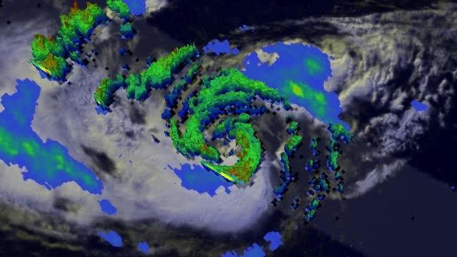
At the time TRMM flew overhead, Cristobal's center was located about 330 miles (531 km) southeast of Cape Hatteras, North Carolina and approximately 420 miles (675.9 km) west-southwest of Bermuda. At this time, an eye was still apparent in TRMM's infrared imagery, but the rain intensities from TRMM showed that there is only a partial eyewall, which is indicated by the band of moderate intensity rain along the northern edge of the storm's center. Several long rainbands of mostly light to moderate rain wrapped mainly around the eastern side of the storm and are evidence of the storm's large cyclonic circulation.
TRMM satellite passed over Cristobal on Aug. 27 at 8:16 a.m. EDT. Cristobal didn't appear round and symmetric in either clouds or rainfall which suggests that the hurricane is being battered by southwesterly wind shear.
(Photo Credit: SSAI/NASA, Hal Pierce)
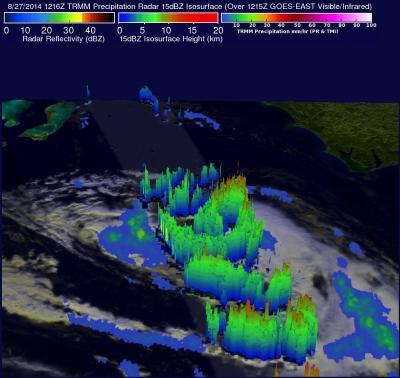
Those rainbands are very well defined in a 3-D image of Cristobal (taken at the same time) that was created at NASA's Goddard Space Flight Center in Greenbelt, Maryland. The 3-D image showed the height of precipitation echoes within the storm courtesy of the TRMM Precipitation Radar instrument. Cristobal didn't appear round and symmetric in either clouds or rainfall which suggests that the hurricane is being battered by southwesterly wind shear ahead of the approaching shortwave trough (elongated area) of low pressure. The National Hurricane Center (NHC) expects that the trough should begin to steer the storm in a more northeasterly direction. At the time of this image, Cristobal's sustained winds were reported at 70 knots (80.5 mph/129.6 kph) and the storm was still moving north at 12 mph (19.3 kph).
By August 28 at 8 a.m. EDT (1200 UTC) the center of Hurricane Cristobal was located near latitude 36.3 north and longitude 67.0 west. Maximum sustained winds remain near 75 mph (120 kph) and no significant change in strength is forecast during the next two days.
Cristobal was moving toward the northeast near 26 mph (43 kph) and that general motion with an increase in forward speed is expected over the next 48 hours. On the forecast track, the NHC noted that the center of Cristobal will rapidly move toward the North Atlantic well northwest of Bermuda and pass well south of Nova Scotia later in the day today, August 28.
With the system now devoid of heavy rain and approaching cooler waters, Cristobal should start to lose its tropical characteristics and transition into an extra-tropical storm over the next few days. The NHC expects Cristobal to become a powerful extra-tropical cyclone over the North Atlantic by Friday night, August 29.
TRMM satellite passed over Cristobal on Aug. 27 at 8:16 a.m. EDT. Several long rainbands of mostly light (indicated in blue) to moderate rain wrap mainly around the eastern side of the storm and are evidence of the storm's large cyclonic circulation.
(Photo Credit: SSAI/NASA, Hal Pierce)
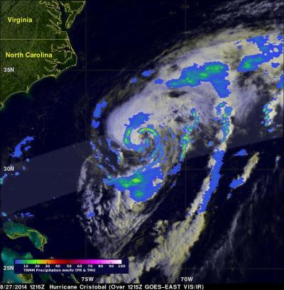
TRMM satellite passed over Cristobal on Aug. 27 at 8:16 a.m. EDT. Several long rainbands of mostly light (indicated in blue) to moderate rain wrap mainly around the eastern side of the storm and are evidence of the storm's large cyclonic circulation.
(Photo Credit: SSAI/NASA, Hal Pierce)
Source: NASA/Goddard Space Flight Center