Over the course of a week, the light brown cloud of ash and smoke can be seen streaming from Popocateptl, and then the white, puffy cumulus clouds develop in the afternoon and sometimes bring rain.
Popocatepetl is located about 34 miles (55 kilometers east of Mexico City. More than 30 million people live within sight of the volcano. "Popocatepetl" is the Aztec word for "smoking mountain," and is North America's second-highest volcano.
According to the U.S. Geological Survey (USGS), on April 17, the volcano's gas and ash plume reached a height of about 980 feet (~300 meters), spreading ash in the nearby town of Puebla. The Alert level at the volcano remains at "Yellow Phase Three," according to Mexico's National Center for Prevention of Disasters (CENAPRED).That alert means explosive activity could escalate, there may be growth of domes or expulsion of magma, and ash could rain on populated areas.
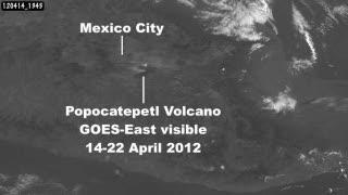
The GOES-13 satellite captured these images of an ash cloud streaming from Mexico's Popocatepetl Volcano and blowing over the town of Puebla, located to the east. The images were captured from April 14 through April 22, 2012.
(Photo Credit: : NASA/NOAA GOES Project)
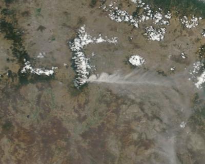
This visible image of the ash plume (light brown) from the Popocatepetl volcano in northern Mexico was captured on April 20,2012 at 16:45 UTC (12:45 pm EDT) from the Moderate Resolution Imaging Spectroradiometer instrument that flies aboard NASA's Terra satellite. The ash was blowing over the town of Puebla, located east of the volcano.
(Photo Credit: NASA MODIS Rapid Response Team)
Source: NASA/Goddard Space Flight Center