Infrared data gathered on the tropical low pressure area known as System 92L gave forecasters a hint that the low would become the Atlantic Ocean hurricane season's second tropical depression.
NASA's Aqua satellite passed over System 92L on July 21 at 11:53 a.m. EDT and the Atmospheric Infrared Sounder (AIRS) instrument gathered infrared data on the developing low pressure area. The infrared data shows temperature, and AIRS data showed some areas of very cold cloud top temperatures, exceeding the threshold of -63F/-52C that indicates cloud tops near the top of the troposphere. Those cloud top temperatures are also indicative of strong uplift (of air) and powerful thunderstorms. Soon after the AIRS data was taken the low that became Tropical Depression 2.
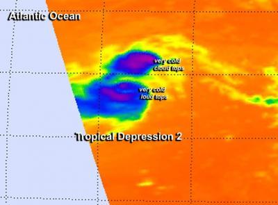
This false-colored infrared image on July 21 at 11:53 a.m. EDT from NASA's Aqua satellite shows some high, cold (purple) thunderstorm cloud tops in the low that became Tropical Depression 2.
(Photo Credit: Image : NASA JPL, Ed Olsen)
At 11 a.m. EDT (1500 UTC) on July 222, the center of Tropical Depression Two (TD2) was located near latitude 12.6 north and longitude 48.0 west, about 910 miles (1,465 km) east of the Lesser Antilles. Tropical Depression Two had maximum sustained winds near 35 mph (55 kph) but the National Hurricane Center (NHC) expects little change in strength over the next 24 hours. The depression is moving toward the west near 17 mph (28 kph) and that general motion is expected to continue for the next couple of days. The estimated minimum central pressure is 1012 millibars.
The NHC noted that Tropical Depression 2 will be moving through an environment of dry air and increasing vertical wind shear that will not favor strengthening. In fact, NHC forecasters expect that TD2 may weaken to a remnant low by Wednesday, July 23, and degenerate into a trough (elongated area) of low pressure on Thursday.
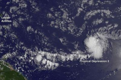
This visible image of Tropical Depression 2 was taken from NOAA's GOES-East satellite on July 22 at 1145 UTC (7:45 a.m. EDT).
(Photo Credit: Image : NASA/NOAA GOES Project)
Source: NASA/Goddard Space Flight Center