Have you ever seen a low pressure area develop into a full-fledged tropical storm? The GOES-13 satellite has and now you can see it in a new animation released today from NASA and NOAA.
System 95L strengthened and became the Atlantic Ocean hurricane season's first tropical storm, named Arlene. It happened at 8 p.m. EDT on June 27 in the southwestern Gulf of Mexico, and the GOES-13 satellite caught the storm coming together.
The Geostationary Operational Environmental Satellite called GOES-13 provides continuous visible and infrared imagery of the eastern U.S. and Atlantic Ocean basin from its position in space. GOES satellites are operated by NOAA, and the NASA GOES Project located at NASA's Goddard Space Flight Center in Greenbelt, Md. creates images and compiled them into the video of the storm as it developed from June 27 to June 28.
The animation includes sped-up infrared and visible frames of data from the GOES-13 satellite and is squeezed down to 25 seconds. The movie shows satellite imagery that was captured in 15 minute intervals from June 27 at 11:15 UTC (7:15 a.m. EDT/6:15 a.m. CDT) until June 28 at 1115 UTC (7:15 a.m. EDT/6:15 a.m. CDT) taking the viewer from the time Arlene was the low pressure area called System 95L to the time she formed off of Mexico's northeastern coastline.
On June 27 when the animation begins at 1115 UTC, it's difficult to pinpoint a center of circulation for System 95L as it was over the Yucatan Peninsula. As the animation goes on, by 1931 UTC (3:31 p.m. EDT) you can start to see the circulation, and the middle of the storm becomes apparent as it moved into the southwestern Gulf of Mexico where it strengthened.
Arlene formed at 8 p.m. EDT on June 28 in the southwestern Gulf of Mexico after it crossed the Yucatan Peninsula as a low pressure system, previously known as System 95L. At that time, its maximum sustained winds were near 40 mph (65 kmh) and it was about 240 miles (380 km) east of Tuxpan, Mexico near 21.2 North and 93.7 West.
Twelve hours later at 8 a.m. EDT on June 28, its sustained winds remained at 40 mph, and it had moved closer to the Mexican coast. Arlene was located about 17 miles (280 km) east of Tampico, Mexico near 21.8 North and 9.2 West. It was moving to the west-northwest near 8 mph (13 kmh) and had a minimum central pressure of 1002 millibars.
Watches and warnings are in effect for northeastern Mexico today as Arlene creeps closer to a landfall in that country. A tropical storm warning is in effect from Barra De Nautla north to Bahia Algodones. Tropical Storm conditions are expected within 24 hours (from 8 a.m. EDT) in that area.
NOAA's National Hurricane Center (NHC) noted that Arlene is expected to produce copious amounts of rainfall between 4 to 8 inches and as much as 15 inches in mountainous areas, which could cause flash flooding and mudslides. Winds are expected to be at tropical storm strength along the coastline, and as Arlene moves inland those winds are expected to weaken. Coastal areas also need to heed a storm surge that could raise water levels by 1 to 2 feet above normal, according to the NHC.
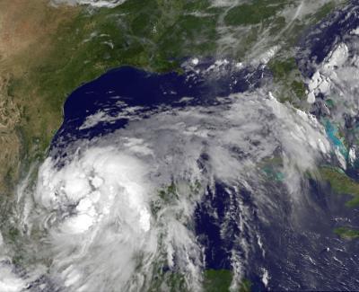
This visible image of Arlene was taken from the GOES-13 satellite on June 29 at 11:31 UTC (7:30 a.m. EDT) and shows the storm just off the northeastern coast of Mexico.
(Photo Credit: NASA/NOAA GOES Project, Dennis Chesters)
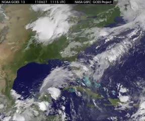
GOES-13 satellite imagery in 15 minute intervals from June 27 at 7:15 a.m. EDT until June 28 at 7:15 a.m. EDT shows Arlene developing from a low pressure area called System 95L off Mexico's northeastern coastline.
(Photo Credit: NASA/NOAA GOES Project, Dennis Chesters)
Source: NASA/Goddard Space Flight Center