The very first tropical cyclone of the Southern Indian Ocean season has been born, and NASA's TRMM satellite captured an image of its rainfall.
On Oct. 12 at 1500 UTC (11 a.m. EDT), Tropical Cyclone 01S (TC01S) was "born" about 90 nautical miles (103.6 miles/166.7 km) west-southwest of Diego Garcia, near 8.3 South latitude and 70.6 East longitude. Diego Garcia is a coral atoll located in the south central Indian Ocean and is part of the British Indian Ocean Territory. It is about 1,970 nautical miles (3,650 km) east of Tanzania, Africa.
TC01S had maximum sustained winds near 35 knots (40 mph/64.8 kph), so no sooner formed, than it became a tropical storm. TC01S was moving to the west-southwest at 6 knots (7 mph/11 kph).
When NASA's Tropical Rainfall Measuring Mission (TRMM) satellite passed over TC01S on Oct. 12 at 0741 UTC (3:41 a.m. EDT), the precipitation radar instrument detected light to moderate rainfall occurring over the center and in a band of thunderstorms wrapping into the center from the southwest. That rain was falling at a rate between .78 to 1.57 inches/20 to 40 mm per hour.
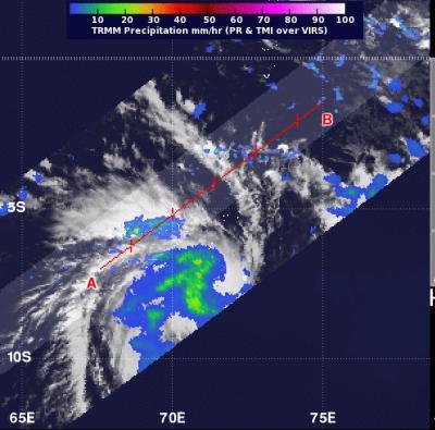
When NASA's TRMM satellite passed over Tropical Cyclone 01S on Oct. 12 at 0741 UTC (3:41 a.m. EDT), light to moderate rainfall (blue and green) was occurring over most of the storm at a rate between .78 to 1.57 inches/20 to 40 mm per hour.
(Photo Credit: : NASA/SSAI, Hal Pierce)
Microwave satellite imagery showed that the system is consolidating, and confirmed the band of thunderstorms wrapping into the center from the southern quadrant.
TC01S is in a good environment to continue strengthening. There is low wind shear and warm waters, two factors that allow a tropical cyclone to intensify.
In last year's season, the first tropical cyclone formed on Dec. 5, 2011, about 545 nautical miles west of the Cocos Islands. This year, we're off to an earlier start.
Forecasters at the Joint Typhoon Warning Center expect TC01S to continue intensifying over the next three days, Oct. 12, 13 and 14, before wind shear increases and sea surface temperatures decrease.
Source: NASA/Goddard Space Flight Center