NASA's Terra satellite passed over Tropical Storm Gordon as it continues to spin up in the North central Atlantic Ocean, and revealed the storm has become less symmetric, indicating it is being battered by wind shear.
When Terra passed over Gordon on August 16, 2012 at 10:25 a.m. EDT (1425 UTC) the Moderate Resolution Imaging Spectroradiometer (MODIS) instrument captured a visible image of the storm. The image showed that the bulk of Gordon's clouds were pushed to the north and northeast as a result of southwesterly wind shear. The MODIS image showed what appeared to be a higher, rounded area of thunderstorms surrounding the center, where the most powerful storms were located. Outer bands of thunderstorms wrapping from the north to the east also contained higher, strong thunderstorms. The wind shear continued on August 17 and Gordon's clouds became less symmetric.
On Friday, August 17, at 5 a.m. EDT (0900 UTC) Gordon's maximum sustained winds were near 65 mph (100 kmh) with higher gusts. The National Hurricane Center (NHC) noted that Gordon could still become a hurricane briefly over the weekend of August 18-19. Gordon is a small storm with tropical storm-force winds extending 60 miles (95 km) from the center, and mostly to the north-northeast.
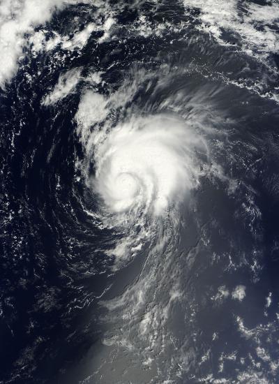
Terra passed over Gordon on Aug. 16, 2012, at 10:25 a.m. EDT (1425 UTC) the Moderate Resolution Imaging Spectroradiometer (MODIS) instrument captured a visible image of the storm. The image showed that the bulk of Gordon's clouds were pushed to the north and northeast as a result of southwesterly wind shear.
(Photo Credit: NASA Goddard MODIS Rapid Response Team)
Gordon was centered about 1,195 miles (1925 km) west of the Azores near latitude 34.6 north and longitude 48.1 west. Gordon is moving toward the east near 18 mph (30 kmh) and it is expected to continue in that general direction. A large trough (elongated area) of low pressure over the northeastern Atlantic Ocean will steer Gordon a little to the south and east for the next couple of days.
Although Gordon is expected to move over somewhat cooler waters, computer models used by the National Hurricane Center still indicate that Gordon may become a hurricane, if just for a short time over the next couple of days and then transition into an extra-tropical storm before reaching the Azores. The NHC noted that Gordon should be approaching the Azores late Sunday, August 19.
Meanwhile, in the far eastern Atlantic, the low pressure area dubbed System 94L has now developed. It is located near 11.3 North latitude and 17.9 West longitude, just west of the African coast. System 94L is producing an area of disorganized showers and thunderstorms. The NHC gives System 94L a 10 percent chance of developing into a tropical depression over the weekend.
Source: NASA/Goddard Space Flight Center