NASA's Tropical Rainfall Measuring Mission satellite, known as TRMM can measure the rate rain is falling with a tropical cyclone from its orbit in space, and data from August 9 reveals areas of heavy rainfall in Tropical Storm Ernesto as it heads for a second landfall in Mexico.
The TRMM satellite saw tropical storm Ernesto on August 9, 2012 at 0656 UTC (2:36 a.m. EDT) after it moved from the Yucatan Peninsula into the Gulf of Mexico. An analysis of TRMM Microwave Imager (TMI) and Precipitation Radar (PR) rainfall shows that powerful convective thunderstorms were dropping rain at a rate greater than 50mm per hour (~2 inches) north of the storm's center.
TRMM Precipitation Radar (PR) data were used to create a 3-D view of Ernesto's vertical structure. The PR view shows that a few of the powerful convective storms near Ernesto's center were pushing to heights of over 16 kilometers (~9.94 miles). The energy released by these storms near Ernesto's center can be a sign of intensification.
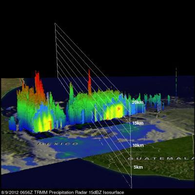
NASA's TRMM satellite saw tropical storm Ernesto on Aug. 9, 2012, at 0656 UTC. This 3-D view of Ernesto's vertical structures shows some powerful convective storms near Ernesto's center were pushing to heights of over 16 kilometers (~9.94 miles).
(Photo Credit: NASA/SSAI, Hal Pierce)
At 10 a.m. EDT on August 9, the National Hurricane Center noted that Ernesto's center was located very close to the coast, or already on land, near 18.2 North and 94.3 West. Ernesto's maximum sustained winds are near 60 mph (95 kmh) with higher gusts, but as Ernesto moves inland it is expected to weaken. Ernesto is moving west near 10 mph (17 kmh) and will move over southern Mexico over the next two days.
A Tropical Storm Warning is in effect from Veracruz to Chilitepec today, August 9. The National Hurricane Center expects the heavy rainfall that NASA's TRMM satellite identified to bring between five to 10 inches of rain, locally up to 15 inches, over the Mexican states of Tabasco, Veracruz, Puebla and Oaxaca. Flash floods and mudslides are a concern with these large amounts of rainfall. In addition another one to two inches of rain are possible over northern Guatemala and the southwestern Yucatan Peninsula.
A visible image of Tropical Storm Ernesto was captured from the Moderate Resolution Imaging Spectroradiometer (MODIS) instrument on NASA's Terra satellite, on August 8, when it was over the Yucatan Peninsula, and before it emerged into the Gulf of Mexico. To see that image, visit: http://tinyurl.com/9cuufa7

NASA's TRMM satellite saw tropical storm Ernesto on Aug. 9, 2012, at 0656 UTC (2:36 a.m. EDT) after it moved from the Yucatan Peninsula into the Gulf of Mexico. Powerful convective thunderstorms were dropping rain at a rate greater than 50mm per hour (~2 inches) north of the storm's center.
(Photo Credit: NASA/SSAI, Hal Pierce)
Source: NASA/Goddard Space Flight Center