Two NASA satellites have captured data on the activity of Typhoon Haikui as it nears the China coast. NASA's Terra satellite provided a visible look at the storm, while NASA's Aqua satellite investigated it in infrared light. Both showed some strong thunderstorms within that were likely packing heavy rainfall.
NASA's Aqua satellite passed over Typhoon Haikui on August 5. The AIRS instrument captured an infrared image of the cloud temperatures that showed the strongest storms and heaviest rainfall in all quadrants of the storm except the northern area. The strongest storms had cloud top temperatures near or exceeding -63 Fahrenheit (-52 Celsius). In an image captured on August 5 at 0441 UTC (12:41 a.m. EDT), those strong storms were seen over Okinawa, Japan. On August 6, 2012 at 0220 UTC NASA's Terra satellite captured a visible image of Haikui. It showed the western edge of the storm brushing mainland China.
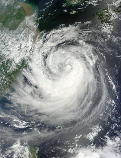
The MODIS instrument onboard NASA's Terra satellite captured this visible image of Typhoon Haikui as it nears landfall in China. This image was captured on Aug. 6, 2012, at 0220 UTC and shows Haikui's western edges brushing eastern China.
(Photo Credit: NASA Goddard MODIS Rapid Response Team)
On August 6 at 0900 UTC (5 a.m. EDT), the center of Haikui was northeast of Ishigakijima, Okinawa, Japan. Ishigakijima is the Okinawa Prefecture's third largest island and is Japan's southernmost city island. Haikui is also about 220 nautical miles (253 miles/407 km) northeast of Taipei, Taiwan. The storm is moving to the west-southwest at 5 knots (5.7 mph/9.2 kmh). Its maximum sustained winds were near 65 knots (75 mph/120 kmh).
Haikui is expected to make landfall south of Shanghai early on August 8.
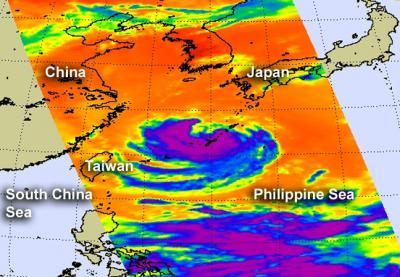
The AIRS instrument onboard NASA's Aqua satellite captured an infrared image of Typhoon Haikui's clouds. The cloud temperatures that showed the strongest storms (purple) and heaviest rainfall in all quadrants of the storm except the northern area.
(Photo Credit: NASA JPL, Ed Olsen)
Source: NASA/Goddard Space Flight Center