Tropical Storm Narelle is growing weaker as it continues to track in a southerly direction parallel to the coast of Western Australia. NASA's Aqua and TRMM satellites captured visible data and rainfall rates on Narelle and noticed the storm was less intense than it was, however, warnings are still up as Narelle continues moving down the coast.
NASA's Aqua satellite passed over Tropical Cyclone Narelle on Jan. 12 at 0615 UTC (1:15 a.m. EST) and Jan. 13 at 0655 UTC (1:55 a.m. EST) and captured these visible images of the storm. The imagery on Jan. 12 showed that Narelle weakened and its eye had become cloud-filled. On Jan. 13, the imagery showed that the southeastern quadrant of the storm was over the northern coast of Western Australia.
NASA's Tropical Rainfall Measuring Mission (TRMM) satellite captured rainfall rates in Cyclone Narelle on Jan. 14 at 0404 UTC. There were no areas of heavy rainfall in the tropical storm. A large area of moderate rainfall was occurring south of the center of circulation, where rainfall rates were near 30 mm (1.18 inches) per hour. TRMM also showed that cloud heights had fallen below 10 kilometers (6.2 miles), indicating weakening in the uplift of air that helps create the thunderstorms that make up the cyclone. Infrared satellite imagery confirmed that the cloud tops were warming, which is another indication of falling cloud heights. The colder a cloud top is, the higher it is, and the stronger the thunderstorm. When cloud tops warm, they're not as high in the atmosphere, and the storms are weaker.
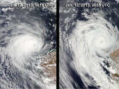
NASA's Aqua satellite passed over Tropical Cyclone Narelle on Jan. 12 at 0615 UTC and Jan. 13 at 0655 UTC and captured these visible images of the storm. Narelle weakened and its eye had become cloud-filled.
(Photo Credit: : NASA Goddard MODIS Rapid Response Team)
On January 14 at 1200 UTC (7 a.m. EST), Tropical Storm Narelle had maximum sustained winds near 45 knots (51.7 mph/83.3 kph). Narelle's center was located near 28.8 south latitude and 110.1 east longitude, about 430 nautical miles (494.8 miles/796.4 km) south-southwest of Learmonth, Australia and is moving to the south at 15 knots (17.2 mph/27.7 kph).
The Australian Bureau of Meteorology (ABM) noted on Jan. 14 that Narelle is not expected to produce gales on the coast. However, west coast tides are likely to rise above the normal high tide mark and coastal flooding is possible in low lying areas.
ABM issue a Strong Wind Warning on Monday, Jan. 14 for the following areas: Gascoyne Coast and Geraldton Coast. For Tuesday, Jan. 15, the Strong Wind Warning will be in effect for: Perth Local Waters, West Kimberley Coast, Gascoyne Coast, Geraldton Coast, Lancelin Coast, Perth Coast, Bunbury Geographe Coast and Leeuwin Coast.
Adverse atmospheric conditions and cooler sea surface temperatures are taking a toll on Narelle as it continues to move in a southerly direction and parallel the coast of Western Australia. Narelle is forecast to turn toward the southeast and become extra-tropical in the next day.
Source: NASA/Goddard Space Flight Center