Friday the thirteenth proved unlucky for Nanauk as environmental conditions worsened and tore the storm apart. By 09:00 UTC (5 a.m. EDT), the Joint Typhoon Warning Center (JTWC) issued their final warning on the tropical cyclone. At that time, maximum sustained winds were near 35 knots (40 mph/65 kph) and weakening quickly. The storm's last official position was at 21.3 north latitude and 64.3 east longitude, about 285 nautical miles (328 miles/528 km) southwest of Karachi, Pakistan. At that time the dissipating storm was moving to the north at 9 knots (10 mph/~17 kph).
JTWC is a joint U.S. Navy and U.S. Air Force office that includes Navy, Air Force and civilian meteorologists and satellite analysts. The center, located in Pearl Harbor, Hawaii, provides forecasts, advisories and warnings on tropical cyclones (the generic name for a typhoon, cyclone, hurricane, tropical storm or tropical depression).
JTWC forecasters examined the upper level of the atmosphere and noted that Nanauk was analysis in an area of strong (40-50 knot/46-57 mph/74-92 kph) northeasterly vertical wind shear that was tearing the system apart.
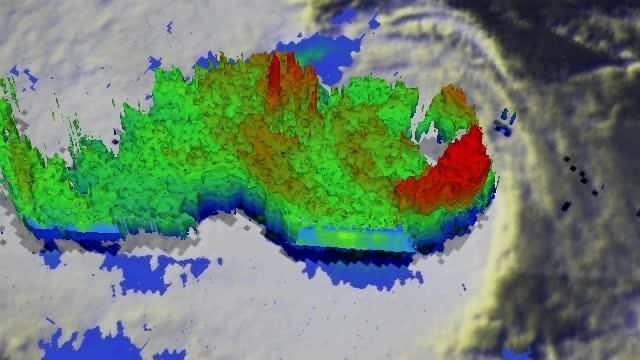
This TRMM satellite flyby animation shows that Tropical Storm Nanauk contained powerful towering thunderstorms that were reaching heights of up to 16.8 km (10.4 miles) on June 11, 2014.
(Photo Credit: Image : SSAI/NASA, Hal Pierce)
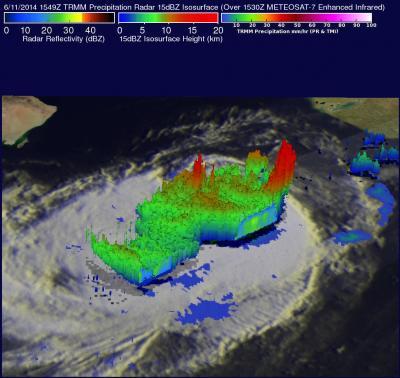
This TRMM satellite 3-D image shows that Tropical Storm Nanauk contained powerful towering thunderstorms that were reaching heights of up to 16.8 km (10.4 miles) on June 11, 2014.
(Photo Credit: Image : SSAI/NASA, Hal Pierce)
Source: NASA/Goddard Space Flight Center