NASA satellite imagery on Aug. 27 showed that wind shear was having an effect on the thunderstorms in Tropical Storm Kong-Rey's northern quadrant.
NASA's Aqua satellite passed over Tropical Storm Kong-Rey on Aug. 27 at 0515 UTC/1:15 a.m. EDT and the Moderate Resolution Imaging Spectroradiometer took a visible image of the storm. The imagery showed that the northern quadrant of the storm had the weakest area of thunderstorm development as a result of northeasterly wind shear, while the southern and western quadrants had strong thunderstorms. Wind shear is expected to relax somewhat, allowing Kong-Rey to intensify over the next day before it begins weakening.
At 1500 UTC/11 a.m. EDT on Aug. 27, Kong-Rey's maximum sustained winds were near 50 knots/57 mph/92.6 kph and the Joint Typhoon Warning Center is predicting a slow intensification. Kong-Rey was centered near 20.5 north and 123.6 east, about 324 nautical miles south-southeast of Taipei, Taiwan. Kong-Rey is moving to the north at 8 knots/9.2 mph/14.8 kph.
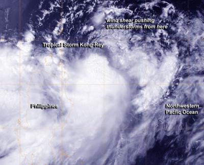
NASA's Aqua satellite passed over Tropical Storm Kong-Rey on Aug. 27 at 0515 UTC and saw the northern quadrant had the weakest area of thunderstorm development as a result of northeasterly wind shear, while the southern and western quadrants had strong thunderstorms.
(Photo Credit: Image : NRL/NASA)
Kong-Rey is expected to pass east of Taiwan and then a mid-latitude trough (elongated area of low pressure) moving in from the northwest is expected to push the storm in a northeasterly direction and weaken it in the next couple of days
Source: NASA/Goddard Space Flight Center