As of 8 a.m. EDT on July 9, a tropical storm warning was in effect for: Barbados, Dominica, St Lucia, Martinique, Guadeloupe, Puerto Rico and southern coast of the Dominican Republic from Cabo Engano to the border with Haiti. In addition, a tropical storm watch was in effect for the U.S. Virgin Islands, Saint Vincent, Vieques and Culebra, Haiti, the northern coast of the Dominican Republic, Turks and Caicos and the southeastern Bahamas.
The National Hurricane Center (NHC) noted that a storm surge of 1 to 3 feet above normal tidal levels can be expected in the Windward and Leeward Islands and Puerto Rico. Along the southern coast of the Dominican Republic, the surge is expected to be higher, reaching 2 to 4 feet. The heavy rainfall that NASA's TRMM satellite observed can be expected over the Leeward and Windward Islands, with totals between 2 to 4 inches, and isolated totals to 6 inches.
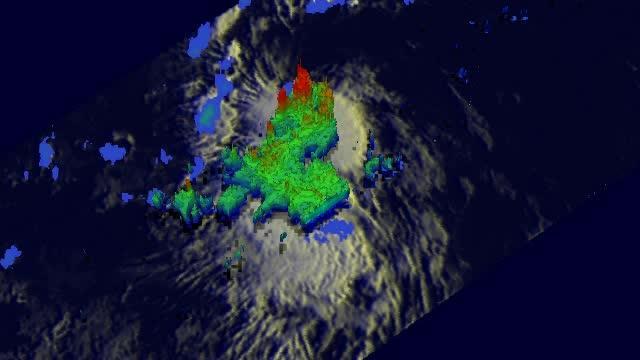
On July 8, NASA's TRMM satellite saw Tropical Storm Chantal's heaviest rainfall happening at a rate of over 115.5 mm/hr. (~4.5 inches) near Chantal's center where thunderstorms reached heights of over 15 km (~9.3 miles).
(Photo Credit: NASA/SSAI, Hal Pierce)
NHC expects tropical storm conditions are expected to affect portions of Windward Islands today, July 9, and Puerto Rico tonight or early Wednesday.
At 8 a.m. EDT Chantal's maximum sustained winds were near 50 mph (85 kph). NHC expects some strengthening. Chantal was centered near 13.8 north latitude and 59.7 west longitude, just 45 miles (70 km) north-northwest of Barbados, and 85 miles east of St. Lucia. Chantal was moving to the west-northwest at a speedy 26 mph (43 kph), and is expected to continue in that general direction for the next couple of days. Minimum central pressure is near 1010 millibars.
Chantal's center is expected to move into the eastern Caribbean Sea during the afternoon and evening of July 9 and near the Dominican Republic by July 10. Current forecast tracks from the NHC bring Chantal along the eastern coast of Florida by the weekend of July 13 and 14.
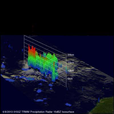
NASA's TRMM satellite showed that the most intense rain falling in Tropical Storm Chantal on July 8 was falling at a rate of over 115.5 mm/hr. (~4.5 inches) near Chantal's center of circulation.
(Photo Credit: NASA/SSAI, Hal Pierce)
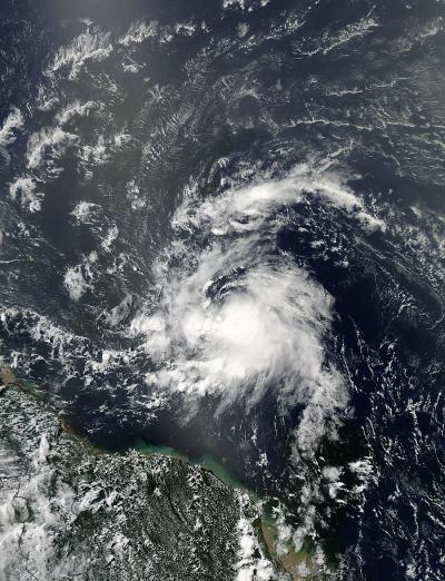
The MODIS instrument aboard NASA's Aqua satellite captured this visible image of Tropical Storm Chantal on July 8 at 1700 UTC (1 p.m. EDT).
(Photo Credit: NASA Goddard MODIS Rapid Response Team)
Source: NASA/Goddard Space Flight Center