On Nov. 29 at 10 a.m. EST/U.S. (1 a.m. CHST local time/ 1500 UTC) Bopha's maximum sustained winds were near 60 mph as it was moving through southern Yap State. The center of Tropical Storm Bopha was located near latitude 3.8 degrees north and longitude 147.4 degrees east. This is about 345 miles southeast of Woleai, and about 400 miles southwest of Weno Island, Chuuk. According to the National Weather Service in Tiyan, Guam, Bopha is expected to pass about 180 miles south of Woleai, on Friday night, Nov. 30. Tropical Storm Bopha is moving west-southwest at 10 mph. Bopha is expected to turn toward the west-northwest with a slight increase in forward speed over the next 24 hours. Bopha is expected to slowly intensify over the next 24 hours, possibly becoming a typhoon later today, Nov. 29 EST/Nov. 30 local time, Guam.
Woleai and surrounding islands can expect wind gusts to 40 mph, dangerous surf between 10 and 12 feet along the southern and eastern shores on Friday, and Saturday, Nov. 30 and Dec. 1. The National Weather Service warns of "coastal inundation 1 to 2 feet may also occur around high tide." Bopha is also expected to bring heavy rainfall on those two days, totaling between 3 to 5 inches.
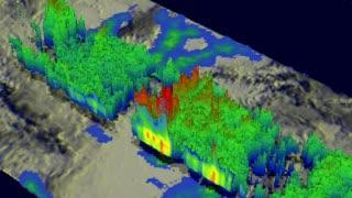
On Nov. 27, 2012, NASA's TRMM satellite revealed that rain in Tropical Storm Bopha was falling at a rate of over 70mm/hour (about 1.75 inches) in the red areas. TRMM showed that powerful storms in the area of the developing eye wall were reaching to heights of about 17km (~10.6 miles).
(Photo Credit: NASA/SSAI, Hal Pierce)
On Nov. 28, the Moderate Resolution Imaging Spectroradiometer (MODIS) instrument aboard NASA's Aqua satellite captured a visible image of Tropical Storm Bopha at 0335 UTC that showed a large "tail" or band of thunderstorms wrapping into the center from the west and south. On Nov. 27, NASA's TRMM satellite flew above Tropical Storm Bopha. On that day, TRMM showed that tropical storm Bopha had an area of very intense convective storms near the center of circulation. TRMM's Microwave Imager (TMI) and Precipitation Radar (PR) data revealed that rain was falling at a rate of over 70mm/hour (about1.75 inches) in that area. TRMM's Precipitation Radar (PR) also showed that powerful storms in the area of the developing eye wall were reaching to heights of about 17km (~10.6 miles). Bopha went on to intensify the next day.
For detailed information about what Faraulep, Woleai and surrounding islands can expect, visit the National Weather Service Office statement: http://www.prh.noaa.gov/data/GUM/HLSPQ1
The current Joint Typhoon Warning Center forecast track takes Bopha south of Hgulu and through the Republic of Palau. This track is more southerly than previously expected and "has greatly diminished the threat of damaging winds at Faraulep," according to the National Weather Service in Guam. Bopha is expected to continue on a west-northwesterly track, with its center passing very close to the island of Palau on Oct. 2. By Oct. 4, the forecasters at the JTWC expect Bopha to make landfall in Visayas, the central Philippines.
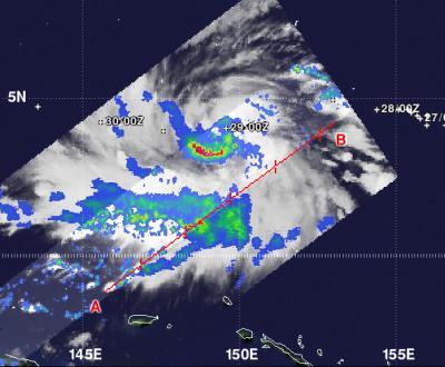
NASA's TRMM satellite captured rainfall rates occurring within Tropical Storm Bopha on Nov. 29 at 0417 UTC, and noticed the heaviest rainfall (red) was occurring south of the center. Rainfall there was occurring at 2 inches (50 mm) per hour.
(Photo Credit: NASA/SSAI, Hal Pierce)
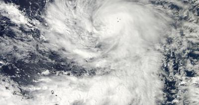
The MODIS instrument aboard NASA's Aqua satellite captured this visible image of Tropical Storm Bopha moving through Micronesia in the western North Pacific Ocean on Nov. 28 at 0335 UTC. Notice the large "tail" or band of thunderstorms wrapping into the center from the west and south.
(Photo Credit: NASA Goddard MODIS Rapid Response Team)
Source: NASA/Goddard Space Flight Center