NASA's TRMM satellite saw that Tropical Storm Ana was still generating moderate rainfall is it pulled away from Hawaii. The next day, NASA's Aqua satellite saw that wind shear was having an effect on the storm as it moved over open ocean.
On Oct. 24, Ana had moved far enough away from land areas that there were no watches or warnings in effect.
The Tropical Rainfall Measuring Mission (TRMM) satellite flew over tropical storm Ana on October 22, 2014 at 1935 UTC (about 8:30 a.m. HST local time). Ana formed over ten days ago but after moving to the northwest of the Hawaiian islands the tropical storm was shown to be still vigorous. A rainfall analysis from TRMM's Microwave Imager (TMI) revealed an area near Ana's center of circulation where rain was falling at a rate of over 40 mm (about 1.6 inches) per hour. TRMM is managed by NASA and the Japan Aerospace Exploration Agency.
NASA's Aqua satellite passed over Tropical Storm Ana on Oct. 24 at 00:25 UTC (Oct. 23 at 8:25 p.m. EDT) and the Moderate Resolution Imaging Spectroradiometer captured a visible image of the storm. The MODIS image showed that there was weak north to north-northwest vertical wind shear that was pushing the clouds and showers away from the center. The MODIS image showed some deep convection and developing thunderstorms mainly along its southeastern semicircle.
On Friday, Oct. 24 at 5 a.m. EDT (0900 UTC/11 p.m. HST, Oct. 23) the center of tropical storm Ana was located near latitude 27.9 north and longitude 170.1 west. That's about 365 miles (585 km) northwest of French Frigate Shoals and 890 miles (1,435 km). Maximum sustained winds were near 50 mph (85 kph). NOAA's Central Pacific Hurricane Center noted that Ana may intensify slightly on Friday, but little significant change in intensity was forecast over the weekend of Oct. 25-26.
Ana is moving toward the north-northwest near 8 mph (13 kph). Ana is expected to begin moving toward the north with a gradual increase in forward speed later tonight and Friday. A rapid acceleration of Ana toward the northeast is expected this weekend.

The MODIS instrument aboard NASA's Aqua satellite captured this image of Tropical Storm Ana in the North Pacific Ocean on Oct. 24 at 00:25 UTC.
(Photo Credit: Image : NASA Goddard MODIS Rapid Response Team)
The Joint Typhoon Warning Center (JTWC) predicts that Ana will continue to move over open waters and undergo extra-tropical transitioning in the next couple of days. By early next week, Oct. 28 or 29 the JTWC expects Ana to be absorbed by a strong extra-tropical low pressure area that is forecast to approach British Columbia, Canada.
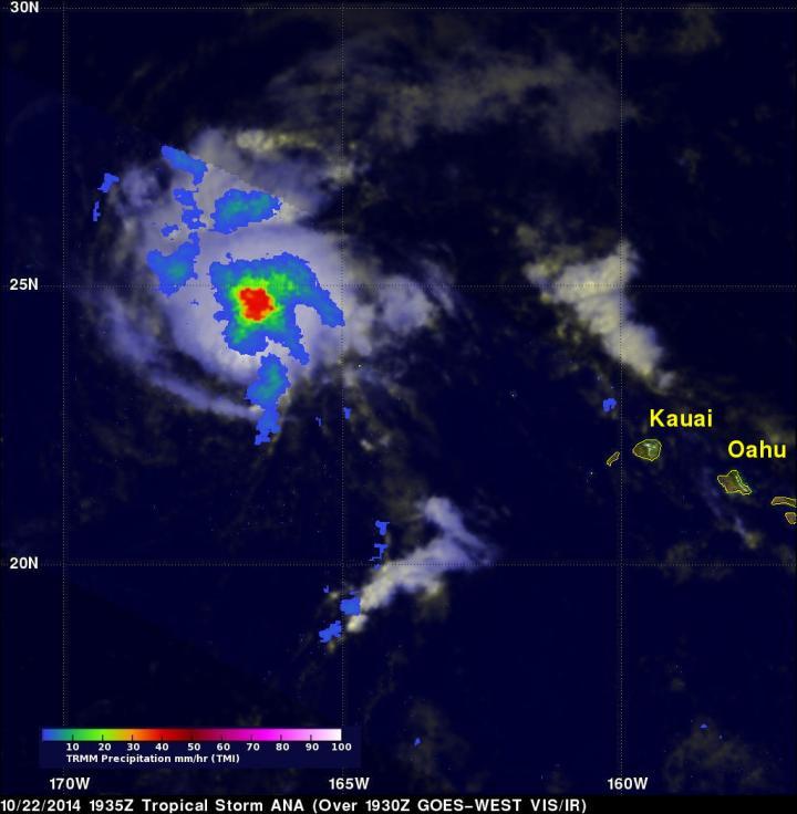
The TRMM satellite flew over tropical storm Ana on October 22, 2014 at 1935 UTC (8:35 a.m. HST) and saw rain falling at 40mm (1.6 inches) per hour (red) near the center.
(Photo Credit: Image : NASA/SSAI, Hal Pierce)
Source: NASA/Goddard Space Flight Center