NASA's Tropical Rainfall Measuring Mission satellite has caught two tropical cyclones with "hot towers" this week, and that's a hallmark that they'll intensify. Tropical Depression 03W is approaching Guam and is expected to strengthen.
"Hot Tower" rain clouds within a tropical cyclone indicate that the storm is going to intensify, and that's what NASA's TRMM satellite spotted in newborn Tropical Depression 2E in the eastern Pacific Ocean and now in Tropical Depression 03W (TD03W) in the western North Pacific Ocean.
A "hot tower" as a rain cloud that reaches at least to the top of the troposphere, the lowest layer of the atmosphere. These towers are called "hot" because they rise to such altitude due to the large amount of latent heat. Water vapor releases this latent heat as it condenses into liquid.
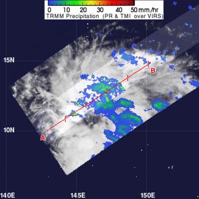
When NASA's TRMM satellite passed over TD03W on May 21, 2012, at 0642 UTC (2:42 a.m. EDT), data revealed a hot tower over 15 kilometers (9.3 miles) high. TRMM also measured rainfall within the tropical depression, and found that isolated areas of heavy rain (falling at a rate of 2 inches/50 mm per hour (appearing in red)) were seen in the western quadrant of the storm. Light to moderate rainfall was falling at a rate between .78 inches and 1.57 inches per hour (20 to 40 mm).
(Photo Credit: NASA/TRMM, Hal Pierce)
When NASA's TRMM satellite passed over TD03W on May 21, 2012 at 0642 UTC (2:42 a.m. EDT), data revealed a hot tower over 15 kilometers (9.3 miles) high. That's an indication that the storm is going to intensify, and that's one factor that forecasters at the Joint Typhoon Warning Center are using in their forecast, which calls for TD03W to become a tropical storm.
TRMM also measured rainfall within the tropical depression, and found that isolated areas of heavy rain (falling at a rate of 2 inches/50 mm per hour) were seen in the western quadrant of the storm. Light-to-moderate rainfall was falling throughout the rest of the storm.
Tropical Depression 03W is close to Guam, just 160 nautical miles south-southeast of Andersen Air Force Base, Guam, near 10.8 North and 145.9 East. It is bringing rain and gusty winds and will continue to do so as it tracks to the west of Guam over the next couple of days and swings to the northeast. Maximum sustained winds are near 25 knots with higher gusts. TD03W is moving to the west, but is expected to turn to the northeast in a couple of days.
Source: NASA/Goddard Space Flight Center