Cloud tops were warming and precipitation was waning in Tropical Depression Genevieve when NASA's Aqua satellite flew overhead. Genevieve moved through all three Pacific Ocean regions (eastern, central and western) in its two week lifetime and met its end today.
NASA's Aqua satellite passed over Tropical Depression Genevieve on Aug. 11 at 01:29 UTC and the Atmospheric Infrared Sounder (AIRS) captured infrared data on the storm. AIRS data showed a small area of the strongest thunderstorms were occurring over the northern quadrant, where temperatures approached -63F/-52C. That area was where where the heaviest rain was located.
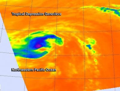
NASA's Aqua satellite passed over Tropical Depression Genevieve on Aug. 11 at 01:29 UTC. A small area of the strongest thunderstorms (purple) were occurring over the northern quadrant.
(Photo Credit: Image : NASA JPL, Ed Olsen)
The Joint Typhoon Warning Center issued its final bulletin on Tropical depression Genevieve on Monday at 2100 UTC (4 p.m. EDT). At that time, Genevieve was located near 34.9 north and 167.6 east, that's about 940 nautical miles north of Wake Island. It was moving to the northwest at 8 knots (9.2 mph/14.8 kph) and maximum sustained winds had dropped to 25 knots (28.7 mph/46.3 kph).
Genevieve was born in the Eastern Pacific, moved through the Central Pacific and into the Western Pacific where it finally became a typhoon, actually a super-typhoon. Genevieve made that Pacific Ocean trek over a period of two weeks and its journey has ended in the Northwestern Pacific Ocean as the storm dissipated on August 12.
Source: NASA/Goddard Space Flight Center