Infrared data from NASA's Aqua satellite today, Sept. 28, revealed strong convection and thunderstorms have built up again in Tropical Storm Nadine as it moved over warm waters in the Eastern Atlantic Ocean. That convection strengthened Nadine back into a hurricane today. Nadine has lasted over two weeks, but is nowhere near breaking the record for longest-lived tropical cyclone.
NASA's Aqua satellite passed over long-lived Nadine on Sept. 28 at 0441 UTC (12:41 a.m. EDT) when it was still a tropical storm and the Atmospheric Infrared Sounder (AIRS) instrument captured an infrared image of the storm. A large area of strong thunderstorms developed around the center of circulation with very cold cloud top temperatures colder than -63 Fahrenheit (-52 Celsius).
On Sept. 27, when NASA's Tropical Rainfall Measuring Mission (TRMM) satellite passed overhead, convection was limited, and rainfall was light around the storm. The TRMM rainfall image showed Nadine had light rainfall surrounding most of the center of circulation. The heaviest intensity of about 20 mm/hour (~0.8 inches) appeared to be located just northeast of the center. That has changed 24 hours later as thunderstorms have re-developed and heavier rainfall appeared in a larger area of the storm.
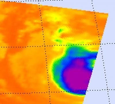
This infrared image was created from AIRS data on Sept. 28 at 0441 UTC (12:41 a.m. EDT) when Nadine was a strengthening tropical storm. Strongest thunderstorms with very cold cloud top temperatures (colder than -63F/-52 C) appear in purple surrounding the center of circulation.
(Photo Credit: : NASA JPL/Ed Olsen)
At 11 a.m. on Sept. 28 Hurricane Nadine's maximum sustained winds had climbed back up to hurricane strength and were near 75 mph (120 kmh). Twenty-four hours before, Nadine's maximum sustained winds near 60 mph (95 kmh). Nadine is currently located near latitude 29.6 north and longitude 34.7 west, about 730 miles (1,175 km) southwest of the Azores Islands. Nadine is moving toward the northwest near 8 mph (13 kmh) and is expected to turn north-northwest over the next day.
Hurricane Nadine marked its seventeenth day of life today, Sept. 28, and is expected to continue lingering through the weekend of Sept. 29 and 30.
Nadine has a long way to go before breaking the record for longest life of a tropical cyclone. According to NOAA, in the Atlantic Ocean, Hurricane Ginger lasted 28 days in 1971. The Pacific Ocean holds the record, though as Hurricane/Typhoon John lasted 31 days. John was "born" in the Eastern North Pacific, crossed the International Dateline and moved through the Western North Pacific over 31 days during August and September 1994. Nadine, however, is in the top 50 longest-lasting tropical cyclones in either ocean basin.
Source: NASA/Goddard Space Flight Center