Tropical Depression 16 formed on Oct. 11 and by 5 p.m. EDT that same day, it strengthened into Tropical Storm Patty. NASA's TRMM and Terra satellite's captured imagery on Patty's rainfall intensity and cloud heights, both of which showed strong, high thunderstorms around the center of circulation.
On Oct. 11 at 11 a.m. EDT the National Hurricane Center (NHC) announced the formation of tropical depression sixteen (TD16) northeast of the Bahamas. Earlier, at 0422 UTC (12:22 a.m. EDT), the Tropical Rainfall Measuring Mission (TRMM) satellite had a look at the disturbed weather associated with the formation of TD16. TRMM's Microwave Imager (TMI) and Precipitation Radar (PR) indicated that surface precipitation was falling at a rate of up to 20mm per hour (~0.8 inches per hour) in the northwestern part of this small area of low pressure.
TRMM precipitation radar data was used to create a 3-D view of the storm that showed that a few of the most powerful convective storms called "hot towers" in the developing tropical depression were reaching altitudes of over 16km (~9.9 miles). NASA research has shown that whenever hot towering thunderstorms are spotted within a tropical cyclone, the storm intensifies within about six hours, and the low pressure area did, becoming Tropical Depression 16. It also intensified further into Tropical Storm Patty by 5 p.m. EDT that day.

TRMM precipitation radar provided this 3-D view of Tropical Depression 16 (before it became Patty) that showed that a few of the most powerful convective storms called "hot towers" in the developing tropical depression were reaching altitudes of over 16km (~9.9 miles).
(Photo Credit: NASA/SSAI, Hal Pierce)
The Moderate Resolution Imaging Spectroradiometer (MODIS) instrument aboard NASA's Terra satellite also captured a visible image of Tropical Depression 16 on Oct. 11. Terra passed over Tropical Depression 16 at 1515 UTC (11:15 a.m. EDT) just six hours before it strengthened into Tropical Storm Patty. Strongest storms around the center cast shadows on lower surrounding thunderstorms indicating that the storm continued to generate a large mass of deep convection.
On Friday, Oct. 12, Patty was drifting at 3 mph (6 kph) south-southwestward near the Bahamas and was already weakening. Tropical Storm Patty had maximum sustained winds near 40 mph (65 kph). Patty's center was located near 25.1 North latitude and 72.5 West longitude, about 230 miles (375 km) east-northeast of the central Bahamas. The National Hurricane Center (NHC) expects Patty to move slowly to the south-southwest or southwest and speed up on Sunday, Oct. 14 while continuing to weaken. In fact, the NHC noted that Patty could become a remnant low pressure area on Saturday, Oct. 13.
Dry and more stable air wrapping around Tropical Storm Patty is the factor that is expected to weaken the storm. The NHC forecasters noted that a low-level ridge (elongated area) of high pressure is building up (strengthening) over the western Atlantic Ocean, and that's going to increase the winds shear from the southwest over the weekend of Oct. 13 and 14, so Patty is likely going to be blown apart in the next day or two.
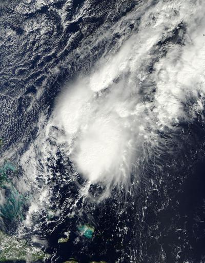
This visible image of Tropical Storm Patty was taken by the MODIS instrument aboard NASA's Terra satellite on Oct. 11 at 1515 UTC (11:15 a.m. EDT). Strongest storms around the center cast shadows on lower surrounding thunderstorms.
(Photo Credit: : NASA Goddard MODIS Rapid Response Team)
Source: NASA/Goddard Space Flight Center