Tropical Storm Talim formed in the South China Sea yesterday, June 18, just south of Hainan Island, China, and NASA's TRMM satellite captured rainfall data right after its birth, revealing some heavy rain.
On June 18, 2012 at 0331 UTC The Tropical Rainfall Measuring Mission (TRMM) satellite saw Talim forming in the South China Sea east of Hainan Island, China. TRMM Microwave Imager (TMI) and Precipitation Radar (PR) data showed that a large area of moderate to heavy rainfall was associated with Talim. TRMM revealed that the heaviest rainfall, dropping at a rate of about 40mm/hr (1.6 inches), was located southeast of Talim's center of circulation.
On June 19, 2012, infrared satellite data from the Atmospheric Infrared Sounder (AIRS) instrument onboard NASA's Aqua satellite showed the convection (rising air that forms thunderstorms that make up the cyclone) was strengthening and expanding around the center. There are also bands of thunderstorms pushed to the southwest, from strong (30 knot) northeasterly wind shear.
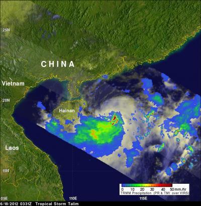
On June 18, 2012 at 0331 UTC the TRMM satellite saw Tropical Storm Talim forming in the South China Sea east of Hainan Island, China. It showed that a large area of moderate to heavy rainfall was associated with Talim. The heaviest rainfall, dropping at a rate of about 40mm/hr (1.6 inches), was located southeast of Talim's center of circulation.
(Photo Credit: : NASA/SSAI, Hal Pierce)
On June 19 at 1500 UTC, Tamil's maximum sustained winds are near 50 knots (57.5 mph/92.6 kph). This storm is about 240 nautical miles (276 miles/444.5 km) in diameter, smaller than Tropical Storm Guchol, which is around 360 miles. Talim is currently centered near 21.6 North and 116.9 East, about 360 nautical miles southwest of Taipei, Taiwan and is moving northeastward at 11 knots (12.6 mph/20.3 kph). It is generating high waves in the South China Sea, with wave heights reaching 26 feet (7.9 meters).
Talim is moving northeast towards the Strait of Taiwan. The system is at peak intensity and will start to weaken as it passes through the Strait of Taiwan, to undergo extra-tropical transitioning to the south of Japan. Currently, it is expected to move across Japan, and that would make it the second tropical storm to hit the big island within a week.
Source: NASA/Goddard Space Flight Center