Tropical Depression Peipah has been very stubborn and has moved over the southern and central Philippines bringing clouds, showers and gusty winds. NASA-NOAA's Suomi NPP satellite captured an image that showed Peipah's clouds covering the Visayas and Mindanao regions of the country.
The VIIRS instrument aboard NASA-NOAA's Suomi NPP satellite captured a visible look at the remnant clouds associated with former Tropical Depression Peipah on April 14 at 4:24 UTC/12:24 a.m. EDT. The Visible Infrared Imaging Radiometer Suite (VIIRS) instrument collects visible and infrared imagery and global observations of land, atmosphere, cryosphere and oceans. Peipah is a broad area of low pressure and its remnant clouds covered the central region of the Philippines called the Visayas region, and Mindanao, the southern region. Microwave satellite imagery confirmed that the low-level part of the storm is still poorly defined and convection (rising air that builds thunderstorms that make up a tropical cyclone) has not improved.
On April 14 at 0900 UTC/5 a.m. EDT, Peipah's remnants were centered near 9.7 north latitude and 130.8 east longitude, about 360 nautical miles/414 miles/666.7 km northwest of Zamboanga, Philippines. Maximum sustained winds were estimated as high as 20 knots/23.0 mph/37.2 kph.
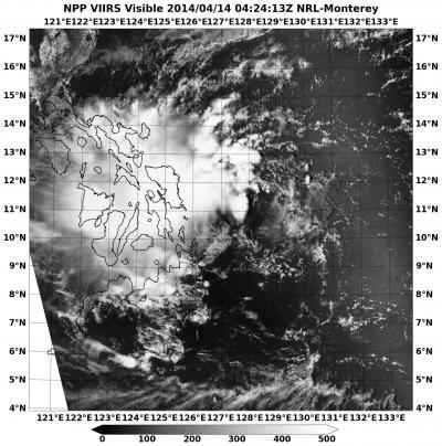
This visible image of Tropical Depression Peipah's remnants over the southern and central Philippines was taken from the VIIRS instrument aboard NASA-NOAA's Suomi NPP satellite on April 14 at 4:24 UTC/12:24.
(Photo Credit: NRL/NASA/NOAA)
According to the Joint Typhoon Warning Center, Peipah's remnants have a medium chance for regenerating in the next couple of days as it moves slowly in a westerly direction.
Source: NASA/Goddard Space Flight Center