Infrared satellite imagery tells the temperature of the cloud tops within a tropical cyclone as well as the sea surface temperatures around the storms. A recent infrared image from NASA's Aqua satellite showed very little strength in the remnants of ex-cyclone Tim offshore from southeastern Queensland.
The Atmospheric Infrared Sounder (AIRS) instrument aboard NASA's Aqua satellite captured an infrared image of Cyclone Tim on March 18 at 0355 UTC (March 17 at 11:55 p.m. EDT). The AIRS image showed that cloud top temperatures had warmed significantly since the previous day as the low pressure area continues to weaken. The coldest cloud top temperatures and strongest thunderstorms appeared in small area offshore from southeastern Queensland.
On March 18 at 1200 UTC (8 a.m. EDT/10 p.m. local time, Brisbane, Queensland, Australia), the remnants of ex-cyclone Tim was located near 19.1 south latitude and 151.7 east longitude, was located about 190 nautical miles (218.6 miles/ 352 km) northeast of Mackay. Tim's remnants were drifting west at 2 knots (2.3 mph/3.7 kph). The Australian Bureau of Meteorology (ABOM) noted that Tim's remnants are causing rough to very rough seas and moderate south to southeasterly swell. According to ABOM, wind gusts to 40 knots (46 mph/74 kph) are possible from Tim's remnants.
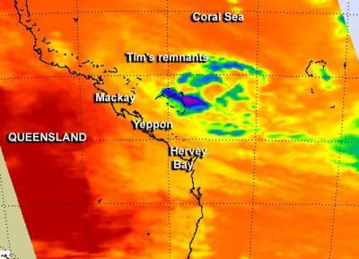
This infrared image of Cyclone Tim was captured on March 18 at 0355 UTC (March 17 at 11:55 p.m. EDT) by the AIRS instrument aboard NASA's Aqua satellite. The coldest cloud top temperatures and strongest thunderstorms appear in small area of purple off shore from southeastern Queensland.
(Photo Credit: NASA JPL, Ed Olsen)
As a result of Tim's close proximity to the Queensland coast, several warnings were posted on March 18 at 2:15 p.m. EDT/U.S. (12:15 a.m. local time, Brisbane on Tuesday, March 19). A Gale Warning is in effect from Townsville to Bowen and from Bowen to Yeppoon, Strong Wind Warnings are in effect from Cardwell to Townsville and from Yeppoon to Double Island Point, including Hervey Bay. A Coastal Waters Wind Warning was also posted for Cardwell to Double Island Point, including Hervey Bay.
ABOM expects Tim's remnants to move in a west-northwest direction towards the Queensland coast over the next few days.
Source: NASA/Goddard Space Flight Center