The Moderate Resolution Imaging Spectroradiometer (MODIS) instrument aboard NASA's Aqua satellite captured a visible image of Tropical Cyclone Evan when it was directly over the Samoa Islands on Dec. 13 at 0105 UTC. Evan's maximum sustained winds had increased to 90 knots (103 mph/166.7 kph).
The other instrument aboard Aqua that captured data from Evan was the Atmospheric Infrared Sounder (AIRS) instrument. AIRS captured an infrared image of Tropical Cyclone Evan at 0059 UTC. The infrared image showed a compact, circular area of strong thunderstorms around Evan's center that reached high into the troposphere where temperatures are as cold as -63 Fahrenheit (-52 Celsius). Those areas also indicated heavy rainfall. Infrared imagery also showed that Evan's eye was about 6 nautical miles wide. Imagery also showed tightly-curved deep convective (rising air that creates the storms that make up the cyclone) banding of thunderstorms were wrapping into the center.
By 1500 UTC (10 a.m. EST) on Dec. 13, Evan's maximum sustained winds had increased to 90 knots (103 mph/166.7 kph). Evan was centered just 65 nautical miles (74.8 miles/120.4 km) west-northwest of Pago Pago, American Samoa, near 13.7 south latitude and 171.7 west longitude. Evan was crawling to the northwest at 2 knots (2.3 mph/3.7 kph).
Evan is expected to track to the west and continue strengthening over the next couple of days.
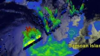
NASA's TRMM satellite passed above an intensifying Tropical Cyclone Evan on Dec. 11 at 1759 UTC (12:59 p.m. EST/U.S.) and saw the tallest thunderstorms around Evan's center of circulation reached 16.5 km (10.25 miles) while other storms tops nearby were measured at 14.75 km (9.17 miles).
(Photo Credit: NASA/SSAI, Hal Pierce)
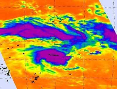
The AIRS instrument aboard NASA's Aqua satellite captured this infrared image of Tropical Cyclone Evan over the Samoa Islands on Dec. 13 at 0059 UTC. Evan's maximum sustained winds had increased to 90 knots (103 mph/166.7 kph) at the time of this image. The purple rounded area is Evan's center of circulation and is populated by strong thunderstorms that reach high into the troposphere where temperatures are as cold as -63 Fahrenheit (-52 Celsius). Those areas shaded in purple also indicate heavy rainfall.
(Photo Credit: NASA/JPL, Ed Olsen)
Source: NASA/Goddard Space Flight Center