The Moderate Resolution Imaging Spectroradiometer or MODIS instrument aboard NASA's Terra satellite captured a visible image of Tropical Cyclone Ita approaching Australia on April 10 at 00:25 UTC. The image showed a cloud-shrouded eye with a thick band of powerful thunderstorms around the center of circulation.
On April 9, Ita was seen twice by NASA and the Japan Aerospace Exploration Agency's Tropical Rainfall Measuring Mission satellite known as TRMM satellite. Ita's wind speeds increased from 65 knots/75 mph with TRMM's first flight overhead at 0536 UTC/1:36 a.m. EDT to 80 knots/92 mph when viewed again at 1528 UTC/11:28 p.m. EDT.
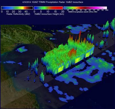
TRMM's Microwave Imager (TMI) and Precipitation Radar (PR) instruments captured data on Tropical Cyclone Ita's rainfall at 1528 UTC/11:28 a.m. EDT. TRMM PR data showed that a maximum rainfall rate of almost 163 mm/6.4 inches per hour was located in the eastern side of Ita's eye wall.
![]()
On April 9, NASA's TRMM saw powerful storms in Ita's eye wall reached heights of over 14 km/8.7 miles. The tallest thunderstorm towers reached heights of over 16 km/9.9 miles high in a feeder band well to the northeast of Ita's eye.
(Photo Credit: NASA/SSAI, Hal Pierce)
TRMM's Precipitation Radar (PR) instrument sliced through Ita's eye and those data were used to create a 3-D "cut-a-way" view. The image showed that powerful storms in Ita's eye wall reached heights of over 14 km/8.7 miles. The tallest thunderstorm towers reached heights of over 16 km/9.9 miles high in a feeder band well to the northeast of Ita's eye.
Ita is continuing to intensify as it moves west, south of Papua New Guinea. The Joint Typhoon Warning Center or JTWC expects the system to peak at 135 knots/155 mph/250 kph on approach to Queensland. JTWC also expects the system will veer sharply southeast on approach to the Australian coastline, and gradually weaken as it passes along the eastern coastline of Queensland. Ita will commence extra-tropical transitioning north of Brisbane.
Current warnings in Queensland are in effect between Lockhart River and Innisfail, extending inland to Kalinga, Laura, Mareeba and Chillagoe. A tropical cyclone watch is in force between Innisfail to Cardwell, extending inland.
On April 9, NASA's TRMM saw powerful storms in Ita's eye wall reached heights of over 14 km/8.7 miles. The tallest thunderstorm towers reached heights of over 16 km/9.9 miles high in a feeder band well to the northeast of Ita's eye.
(Photo Credit: NASA/SSAI, Hal Pierce)
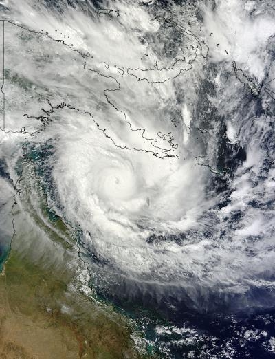
NASA's Terra satellite captured this image of Tropical Cyclone Ita approaching Australia on April 10 at At 00:25 UTC.
(Photo Credit: NASA MODIS Rapid Response Team)
Source: NASA/Goddard Space Flight Center