The National Hurricane Center noted on August 22 that Irene is expected to produce total rainfall accumulations of 5 to 10 inches across Puerto Rico, The Virgin Islands, the Dominican Republic, Haiti, the Southeastern Bahamas and The Turks and Caicos Islands. Isolated maximum amounts of rainfall may reach up to 20 inches.
In addition to the TRMM satellite, NOAA's Geostationary Operational Environmental Satellite, GOES-13 has documented the birth of Irene from a low pressure area called System 99L over the weekend. The NASA GOES Project at NASA Goddard Space Flight Center in Greenbelt, Md. compiled four days of animations to show the development and movement of Hurricane Irene and former Tropical Storm Harvey.
A GOES-13 animation from August 19 through August 22 (1545 UTC/11: 45 a.m. EDT) shows the progression of Tropical Storm Harvey through the western Caribbean Sea. Over the weekend, Harvey made landfall in Belize and is moving into Mexico today. Farther to the east, the animation shows the development of the low pressure area called System 99L into Hurricane Irene on August 20 that moved over Puerto Rico and is now moving west-northwest into the eastern Caribbean today. Irene's maximum sustained winds on the morning of August 22
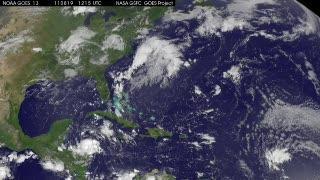
A GOES-13 animation from Aug. 19 through August 22 (1545 UTC/11: 45 a.m. EDT) shows the progression of Tropical Storm Harvey through the western Caribbean Sea and the birth of Hurricane Irene. Over the weekend, Harvey made landfall in Belize and is moving into Mexico today. Farther east, System 99L developed into Hurricane Irene on August 20. Irene moved over Puerto Rico and is now moving west-northwest toward the southeastern Bahamas today.
(Photo Credit: NASA/NOAA GOES Project)
were near 75 mph. The 35 second video shows more than three days of development and movement of Harvey and Irene.
The National Hurricane Center has posted a whole host of hurricane warnings and watches today. A Hurricane Warning is in effect for the North Coast of the Dominican Republic from the Haiti border east to Cabo Engano. A Hurricane Watch is in effect for the north coast of Haiti from Le Mole St. Nicholas eastward to the Dominican Republic border and the central Bahamas. Tropical storm conditions will reach the northern portion of the Dominican Republic by this afternoon.
A Tropical Storm Warning is in effect for the U.S. Virgin Islands, the British Virgin Islands, the south coast of the Dominican Republic, all of Haiti and the southeastern Bahamas and the Turks and Caicos Islands. The warning has been changed from hurricane to tropical storm warning for Puerto Rico, Vieques and Culebra as Irene is moving away.
At 9 a.m. EDT, August 22, Irene was moving away from Puerto Rico and toward the Southeastern Bahamas. Irene's maximum sustained winds were near 75 mph (120 kmh) and it was moving to the west-northwest near 14 mph (22 kmh). Irene's center was about 55 miles (90 km) west-northwest of San Juan, Puerto Rico near 18.8 North and 66.8 West. Irene's minimum central pressure was 987 millibars.
Irene is forecast to reach Florida later this week and if it makes landfall as a hurricane, it would be the first landfalling hurricane in the mainland U.S. in three years. The last landfalling U.S. storm was Hurricane Ike in Galveston, Texas in 2008.
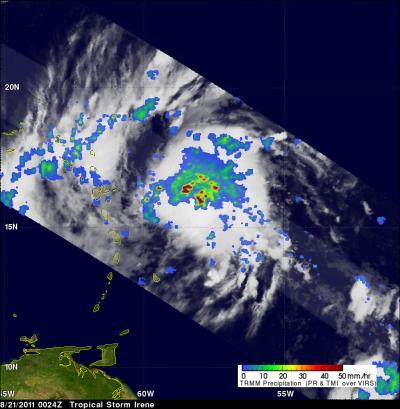
The TRMM satellite passed over Irene when it was a tropical storm on Aug. 21 2011 at 0024 UTC (8:24 p.m. EDT Aug. 20). Data collected with this orbit showed that Irene contained numerous powerful thunderstorms with TRMM's Precipitation Radar (PR) revealing that some thunderstorm towers near the center of the storm were reaching to heights above 15 km (~9.3 miles).
(Photo Credit: NASA/SSAI, Hal Pierce)

This visible image was taken from the MODIS instrument on NASA's Aqua satellite on Aug. 21, 2011 at 17:45 UTC (1:45 p.m. EDT) when Irene was still a tropical storm approaching Puerto Rico (left).
(Photo Credit: NASA Goddard MODIS Rapid Response Team.)
Source: NASA/Goddard Space Flight Center