Post-tropical cyclone John has been "flushed" out of existence in the eastern Pacific Ocean, and infrared NASA imagery revealed warmer cloud top temperatures and virtually no precipitation from John's remnants on Sept. 4.
When NASA's Aqua satellite flew over post-tropical storm John on Sept. 4 at 21:23 UTC (5:23 p.m. EDT) the Atmospheric Infrared Sounder (AIRS) instrument revealed that cloud top temperatures in the storm had warmed over the previous 24 hours. AIRS data also showed there was one very tiny area of convection (rising air that forms the thunderstorms that make up a tropical cyclone) in the southwestern quadrant of the entire low pressure area. The AIRS infrared data showed a circular swirl of clouds where temperatures were around 270 kelvin (26.3 F/-3.1 C), which are warm in terms of cloud top temperatures for thunderstorms. When cloud top temperatures reach the AIRS data threshold of -63F/-52C, they are considered strong thunderstorms.
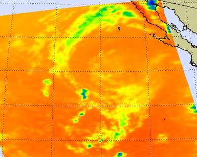
NASA AIRS infrared data on Sept. 4 at 5:23 p.m. EDT showed a circular swirl of clouds in post-tropical storm John where temperatures were around (yellow) 270 kelvin (26.3 F/-3.1 C), which are warm in terms of cloud top temperatures for thunderstorms.
(Photo Credit: NASA JPL, Ed Olsen)
The last advisory on John was issued by the National Hurricane Center on Sept. 4 at 2100 UTC (5 p.m. EDT), just before the AIRS image was captured by NASA's Aqua satellite. The 5 p.m. advisory put John's center about 505 miles west-northwest of Cabo San Lucas, Mexico, near 24.3 North and 117.7 West. John's maximum sustained winds were near 35 mph (55 kmh) and weakening. The remnants of John were moving to the northwest at 12 knots (13.8 mph/22.2 kmh) as the low pressure area continued to weaken. John is expected to dissipate later today.
Source: NASA/Goddard Space Flight Center