Cyclone Irina has lived a long life and caused a lot of trouble, damages and death over the course of its life, and it appears to be finally fading over the Mozambique Channel.
On March 8 at 1500 UTC (10 a.m. EST), Irina's winds had finally dropped below 45 knots (51.7 mph/83.3 kph) to 35 knots (40.2 mph/64.8 kph) making it a minimal tropical storm. Irina was still in the southern Mozambique Channel, centered near 29.5 South and 37.8 East. That is about 350 miles southeast of Maputo, Mozambique. Irina is moving to the west at 8 knots (9.2 mph/14.8 kph).
The Moderate Resolution Imaging Spectroradiometer (MODIS) instrument on NASA's Aqua satellite captured this visible image of Cyclone Irina on March 9 at 1048 UTC (5:48 a.m. EST) that showed the bulk of clouds and showers south of the center of circulation, with some outer bands of thunderstorms to the west.
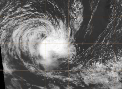
The MODIS instrument on NASA's Aqua satellite captured this visible image of Cyclone Irina on March 9 at 1048 UTC (5:48 am EST). The strongest part of the storm is south of the center, and wind shear is now taking a toll on the storm's strength.
(Photo Credit: : NRL/NASA)
Infrared satellite imagery shows that the strongest thunderstorms, located in the southeastern quadrant have weakened and are being pushed away from the center from wind shear. Once a tropical cyclone is no longer "stacked" vertically on top of itself, it weakens, and that's what is happening to Irina.
In addition to increased wind shear, sea surface temperatures are below the 80 degree Fahrenheit threshold (26.6 C) needed to maintain a tropical cyclone, so the cooler waters are preventing evaporation and energy feeding into the storm.
The Joint Typhoon Warning Center expects that Irina will finally dissipate at sea over the weekend.
Source: NASA/Goddard Space Flight Center