The low pressure area formerly known as System 92S has strengthened overnight and developed into Tropical Storm Errol today, April 15. Infrared imagery from NASA's Aqua satellite showed strong thunderstorms near Errol's center, but they remained off-shore from Western Australia's northern coast.
An infrared image on April 14 at 0517 UTC (2:47 p.m. Australia/Darwin local time) from NASA's Atmospheric Infrared Sounder (AIRS) instrument (that flies aboard NASA's Aqua satellite) shows that Tropical Storm Errol's strongest thunderstorms with the coldest, highest cloud tops were off-shore from the northern coast of Western Australia. Those thunderstorms had cloud-top temperatures as cold as or colder than -63 F/-52C and brought heavy rainfall.
Multispectral satellite imagery also showed a well-defined center of circulation in Errol, and bands of thunderstorms wrapping around its souther and western edges.
Tropical Storm Errol has sustained winds of 40 knots (46 mph/74 kmh) with higher gusts, and is kicking up rough surf along the northern coast of Western Australia today. Errol's center was about 270 miles (434 km) west of Darwin, Australia near 13.1 South latitude and 126.3 East longitude. Errol is currently drifting south-southwestward at 2 knots (2 mph/~4 km) but is expected to start moving to the west-northwest as a result of a strengthening ridge of high pressure building up over Western Australia.
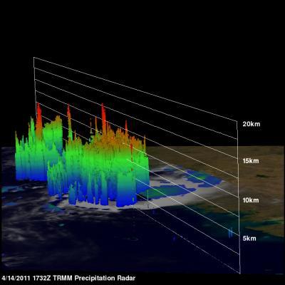
This 3-D image from NASA's TRMM satellite showed Errol's strong thunderstorms (red) and heavy rainfall on April 14. Some of the strongest thunderstorm cloud tops were 9 miles high (15 km).
(Photo Credit: NASA/SSAI, Hal Pierce)
Forecasters at the Joint Typhoon Warning Center (JTWC) take the storm westward and out to the open waters of the Southern Indian Ocean over the next couple of days, which is good news for residents of Western Australia. However, dangerous surf will continue with gusty winds and heavy downpours over the weekend as Errol moves away. Currently the JTWC notes that Errol is kicking up 12-foot (~3.5 meter) high seas.
The Australian Bureau of Meteorology (ABoM) noted that Errol may intensify on April 16 as it continues to move away from the Kimberley coast of Western Australia. ABoM has posted a Blue Alert for residents who live in areas between Kalumburu and Kuri Bay, including coastal and island communities. The ABoM forecast notes that wind gusts as high as 68 mph (110 kmh), just a little below hurricane-strength, may be experienced along coastal areas from Kalumburu and Kuri Bay later tonight (April 15) or Saturday (April 16) morning depending on the Tropical Storm's movement. Errol is also expected to bring heavy rainfall, so residents should be on guard for local flooding especially in the northern areas of the Kimberley.
Errol is forecast to track west into the Indian Ocean and remain south of the main Indonesian islands.
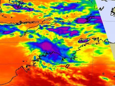
This infrared image from NASA's AIRS instrument shows that Tropical Storm Errol's strongest thunderstorms with the coldest, highest cloud tops (purple) are off-shore from the northern coast of Western Australia on April 14 at 0517 UTC. The purple areas represent cloud-top temperatures as cold as or colder than -63 F/-52C.
(Photo Credit: NASA/JPL, Ed Olsen)
Source: NASA/Goddard Space Flight Center