The former tropical storm Alessia reclaimed her title on November 27 in the Gulf of Carpentaria, as NASA's TRMM satellite passed overhead and observed heavy rainfall occurring in bands of thunderstorms around the storm's center.
NASA's Tropical Rainfall Measuring Mission or TRMM satellite passed directly above newly transformed Tropical Storm Melissa's center of circulation on November 27, 2013 at 02:25 UTC/10:25 p.m. EST on Nov. 26. TRMM's Precipitation Radar (PR) instrument found that rain was falling at a maximum rate of 50 mm/2.0 inches per hour west of the center, and in a large band of thunderstorms stretching from the east to the south.
On November 27 at 0900 UTC/4 a.m. EST Alessia's maximum sustained winds were near 35 knots/40 mph/62 kph. Alessia's center was located near 15.9 south latitude and 137.7 east longitude, about 105 nautical miles/120 miles/194.5 km west-northwest of Mornington Island, Australia. Alessia was moving to the east southeastward at 3 knots/3.4 mph/5.5 kph.

The MODIS instrument aboard NASA's Terra satellite captured this visible image of the reborn Tropical Storm Alessia in the southern Gulf of Carpentaria on Nov. 27 at 01:05 UTC.
(Photo Credit: : NASA Goddard MODIS Rapid Response Team)
Mornington Island is located in the southern part of the Gulf of Carpentaria, and is part of the state of Queensland. The Gulf of Carpentaria is a shallow sea that is surrounded by land on three sides and the Arafura Sea to the north. The Northern Territory borders the Gulf on its west and south sides, while Queensland borders the Gulf to the east and southeast.
On November 27, the Australian Bureau of Meteorology or ABM, posted a Cyclone Warning for coastal areas from Port Roper to Mornington Island, and a Cyclone Watch was in effect for coastal areas from Mornington Island to Burketown. The Cyclone Watch from Burketown to Karumba was cancelled. Heavy rainfall and abnormally high tides may cause flooding in low lying areas Roper-McArthur District and coastal areas in Queensland Gulf Country west of Mornington Island, according to the ABM forecast. For updated warnings, visit: http://www.bom.gov.au/qld/warnings/.
Alessia is now forecast to make another landfall, and this time the final one, just west of Mornington Island on the mainland in Australia's Northern Territory. The Joint Typhoon Warning Center expects Alessia's landfall to occur on November 28 around 0600 UTC/1 a.m. EST. Thereafter, Alessia is expected to track to the south-southeast, further inland where it will dissipate.
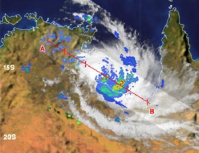
NASA's TRMM satellite saw Alessia's rebirth on Nov. 27 in the Gulf of Carpentaria. Heavy rainfall (red) was occurring in bands of thunderstorms circling the storm.
(Photo Credit: : SSAI/NASA, Hal Pierce)
Source: NASA/Goddard Space Flight Center